Australia
K'gari
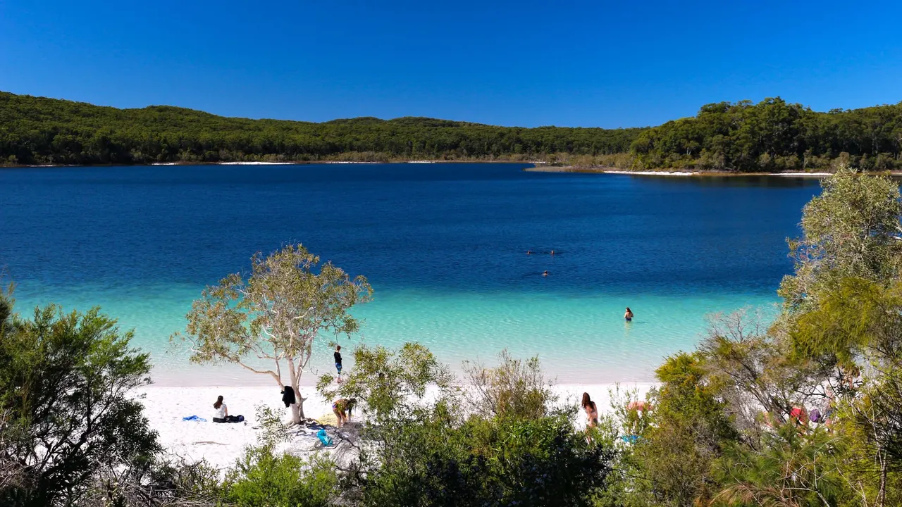
Lake McKenzie from above through the bush
- Nature & outdoors88
- Beaches68
- Families38
Photo: Lucas·G, CC BY-SA 4.0, cropped
Match
27
Every category weighted equally
- Beach & sun34
- Culture & arts17
- Food & nightlife16
- Family trip34
- Outdoors37
- Relax & unwind35
- Shopping & style18
- On a budget26
K'gari in twelve categories
Our verdict on each, scored 0 to 100 against the same fixed benchmark cities, so a score means the same thing on every page.
Beaches & swimming. Scores 68 out of 100.
Food & drink. Scores 15 out of 100.
Culture & sights. Scores 15 out of 100.
Nightlife. Scores 3 out of 100.
Nature & outdoors. Scores 88 out of 100.
Day trips. Scores 10 out of 100.
Good for families. Scores 38 out of 100.
Getting around. Scores 15 out of 100.
Shopping & style. Scores 3 out of 100.
Affordability. Scores 25 out of 100.
Live music & performing arts. Scores 2 out of 100.
Wellness & relaxation. Scores 38 out of 100.
K'gari category by category
Beaches & swimming
68The island's long eastern ocean beach is spectacular to look at but not a place to swim. The surf is unpatrolled, rips are strong and sharks are present, so the sand works as a road and a lookout rather than a bathing beach.
The swimming happens inland and in sheltered spots instead. Lake McKenzie's white silica sand and clear blue water are the island's best-known swim, and Lake Birrabeen, Lake Boomanjin and Lake Wabby offer more of the same, quieter. Eli Creek runs cold and clear down to the beach for a lazy float, and the rock-fringed Champagne Pools near Indian Head take the ocean safely. On the calm western shore around Kingfisher Bay the water is flat and shallow. Expect water of about 25°C in summer, cooler in winter.
Food & drink
15Eating on the island is practical rather than a pleasure in itself. The resort at Kingfisher Bay and the small settlements at Eurong and Happy Valley have a few restaurants, bars and general stores, and campers bring most of their food across on the ferry. Fresh seafood and good cooking are found back on the mainland, so plan meals as supplies rather than as part of the trip.
Culture & sights
15The island's sights are almost all natural. The rusting hull of the Maheno, a liner beached in a 1935 cyclone, is the one landmark everyone stops at, and Central Station keeps traces of the old logging days in the rainforest. The Butchulla people's long connection to the island, whose name means paradise in their language, can be learnt about through ranger talks and guided walks, but there are no museums or historic towns to fill a day.
Nightlife
3There is no nightlife to speak of. The resort bars close early, campers gather around their own fires, and most people are asleep in time for an early start on the tide. The nights are better used for stargazing over the dunes.
Nature & outdoors
88This is the largest sand island in the world, and its landscape is unlike anywhere else. Tall rainforest grows straight out of sand around Pile Valley and Central Station, more than a hundred freshwater lakes sit in the dunes, and moving sand blows such as the one swallowing Lake Wabby cut through the bush. Along the eastern coast, coloured sand cliffs at the Pinnacles and the headland at Indian Head look out over rays, turtles and, from July to October, migrating humpback whales.
Wild dingoes roam the beaches and are the island's signature animal. The Great Walk links lakes and forest over several days, and driving the beach by 4WD is a large part of the experience. Summer brings heat and storms, and winter is the clearest season.
Day trips
10The island is the outing, not a base for others. Leaving it means a barge back to the mainland, where Hervey Bay and Rainbow Beach are pleasant but low-key seaside towns. Most visitors spend their days moving between the island's own lakes, forests and beaches, and treat the mainland as the place they arrive and leave from.
Good for families
38For families with school-age children who like an adventure, the island is memorable: floating down Eli Creek, swimming in the clear lakes, spotting whales and camping in the dunes. The resort at Kingfisher Bay, with its pools and calm western beach, is the easiest base.
It is harder with toddlers. Dingoes are wild and have attacked children, so the young ones must stay within arm's reach at all times and many campsites are fenced. There is nothing built for children, the ocean is not for swimming, and days involve long, bumpy drives on sand.
Getting around
15Reaching the island takes a vehicle barge or passenger ferry from River Heads near Hervey Bay or from Inskip Point near Rainbow Beach. Once across, there are no sealed roads. Everything is reached by high-clearance 4WD on soft inland tracks and along the ocean beach, which can only be driven around low tide.
Visitors without off-road experience usually join a guided tour or stay at a resort that runs them, which is the simplest way to see the main sights. Self-drivers need a permit, patience and good timing with the tides.
Shopping & style
3There is no shopping beyond general stores for supplies, fuel and ice, and a gift shop at the resort. Stock up on the mainland before crossing.
Affordability
25It is an expensive trip for most people. Barge crossings, 4WD hire or a guided tour, and the limited resort rooms all add up, and food and fuel on the island cost more than on the mainland. Travellers who bring their own vehicle and camping gear can keep costs much lower, but those relying on tours and resorts pay well.
Live music & performing arts
2There are no performances to attend beyond the occasional musician at a resort bar. This is not a place for live music or theatre.
Wellness & relaxation
38There is no bathing culture here, and spa treatments are limited to the resort at Kingfisher Bay. What the island does offer is quiet. Mornings by a still lake, forest walks without crowds and evenings away from phone signal give a slow pace that many find restorative, provided the long drives on sand are not the main part of the stay.
Where to stay in K'gari
The main choice is between the calm western shore and the ocean beach on the east. Kingfisher Bay, on the western side, is the easiest base. The resort there has pools, flat shallow water and guided 4WD tours that leave from the door. It suits families, first-timers with no off-road experience and anyone who wants a restaurant and a spa treatment at the end of the day. The ferry from River Heads lands close by.
Eurong and Happy Valley are the two small settlements on the eastern beach, and both sit on the sand route that serves as the island's main road. Eurong is within easy reach of Lake McKenzie, Lake Wabby and Central Station, so it works well for self-drivers exploring the lakes and forest. Happy Valley lies further north, nearer Eli Creek, the Maheno and the Pinnacles, and is quieter still. Both have a few rooms, a general store and little else.
Campers get the most freedom, and the dune and forest campsites, some of them fenced against dingoes, give the quietest nights and the best stargazing. Visitors short on time or money can stay in Hervey Bay or Rainbow Beach and cross for a day tour, though even one night on the island lets you see far more. Most trips keep a single base and drive out each day, planning around the tides.
When should you go?
Pick a month to see what it is like. The climate figures are measured averages, not a forecast.
K'gari in July
Daytime high, °C
Rainfall in the month, mm
The whole year
Shaded against this destination’s own year: the deepest cell is its best month for that figure and the palest its weakest.
Where the figures come from
K'gari's temperatures are measured 25 km from the centre, at Hervey Bay.
K'gari has no rain gauge within 25 km of the centre, so its rainfall comes from a gridded climate dataset read at the destination rather than from a gauge further away.
Temperature and rainfall are climate normals, averaged over the years shown. K'gari: 1991-2020 normals, Hervey Bay (25.4 km from centre).
Before you go
| Measure | K'gari |
|---|---|
| Official language | English |
| Currency | Australian Dollar (AUD) |
| Sockets | I230 V, 50 Hz |
| Driving side | Left |
| Time zone | UTC+10 |
| Emergency number | 000 |
| Main airport | Hervey Bay Airport (HVB)3 non-stop destinations |
| Public holidays this year | 11 days |
By the numbers
| Measure | K'gari |
|---|---|
| Population | 152 |
| Swim season, months above 21 °C | 10 months |
Compare K'gari with
Every comparison with a written verdict behind it.