Chile
Torres del Paine
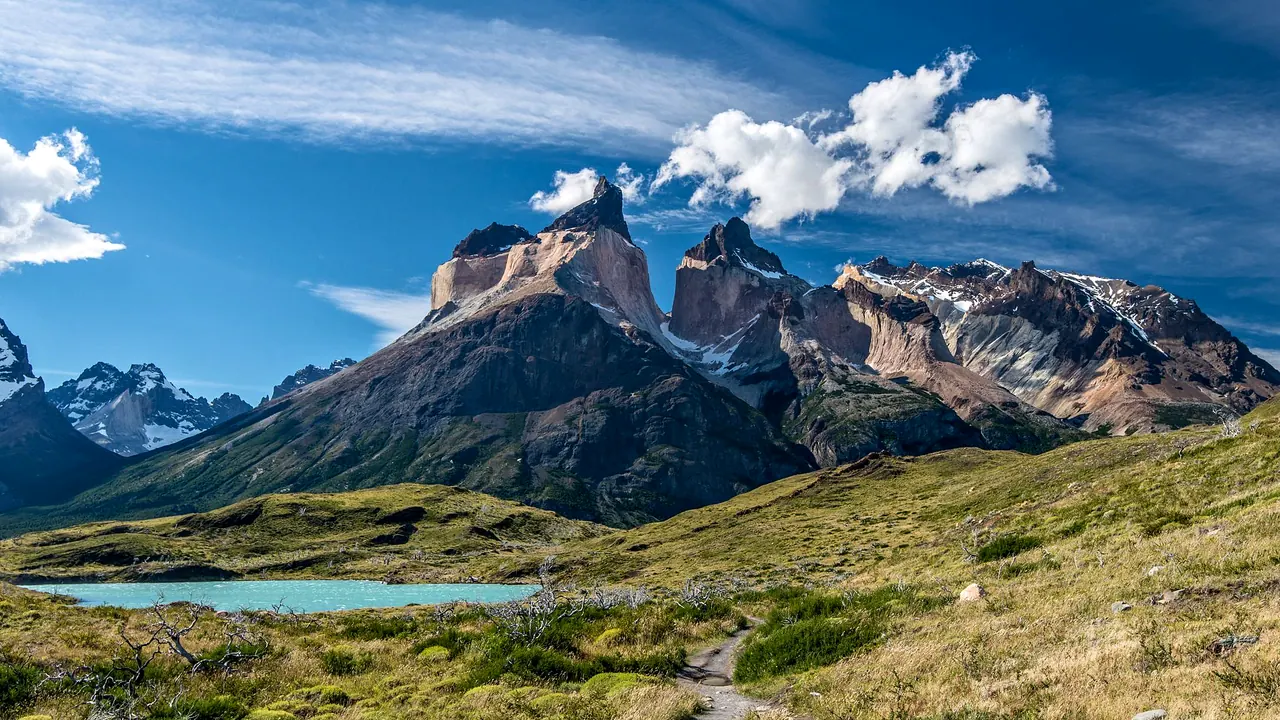
The Cuernos del Paine under a clear sky
- Nature & outdoors97
- Wellness & relaxation35
- Food & drink27
Photo: Holger J. Bub, Pexels License
Match
22
Every category weighted equally
- Beach & sun23
- Culture & arts17
- Food & nightlife16
- Family trip24
- Outdoors31
- Relax & unwind27
- Shopping & style18
- On a budget21
Torres del Paine in twelve categories
Our verdict on each, scored 0 to 100 against the same fixed benchmark cities, so a score means the same thing on every page.
Beaches & swimming. Scores 3 out of 100.
Food & drink. Scores 27 out of 100.
Culture & sights. Scores 9 out of 100.
Nightlife. Scores 6 out of 100.
Nature & outdoors. Scores 97 out of 100.
Day trips. Scores 10 out of 100.
Good for families. Scores 22 out of 100.
Getting around. Scores 20 out of 100.
Shopping & style. Scores 9 out of 100.
Affordability. Scores 17 out of 100.
Live music & performing arts. Scores 3 out of 100.
Wellness & relaxation. Scores 35 out of 100.
Torres del Paine category by category
Beaches & swimming
3This is not a place to swim. The lakes are glacier-fed and very cold, often only a few degrees above freezing, and the Patagonian wind makes even a paddle uncomfortable. The fjord at Puerto Natales is a grey working waterfront, not a beach. People come here to walk, and anyone who wants a beach needs a separate trip far to the north.
Food & drink
27The food here comes from the Magallanes steppe and the southern sea. Patagonian lamb roasted on a cross over an open fire is the dish to look for, with centolla (southern king crab), local trout and drinks flavoured with calafate berries. Puerto Natales has a short street of restaurants, a few brewpubs and cafés that feed returning trekkers well.
Inside the park the choice comes down to where you sleep. The upmarket lodges serve careful set menus, the refugios serve hearty set meals to walkers, and campers cook their own. It is honest, filling food, but the range is small, and nobody comes for the eating.
Culture & sights
9There is little built heritage to see. Near Puerto Natales, the Milodon Cave tells the story of an extinct giant ground sloth and of early human settlement. The old Puerto Bories meat-freezing works on the fjord recalls the sheep-ranching era that shaped this corner of Patagonia, and a small municipal museum covers the same history. Beyond that, the sights here are mountains rather than monuments.
Nightlife
6Evenings are for a beer and an early night before the next day's walk. In Puerto Natales a few brewpubs and bars fill with trekkers swapping trail stories, and they can be friendly and lively in summer, but there are no clubs and nothing runs late. In the park, the night ends at the lodge bar or the refugio dining room. Long southern summer days mean it is often still light at bedtime.
Nature & outdoors
97This is one of the great mountain landscapes on earth. The granite Towers and the dark-capped Cuernos rise straight out of the steppe above milky-turquoise lakes. Grey Glacier calves icebergs into its lake, and the wind sweeps over the open land with a force you remember. The W Trek, which takes four or five days between refugios and campsites, and the longer O Circuit around the whole massif are classics. Day walks to the base of the Towers or to the Mirador Cuernos give a taste without the full trek.
The wildlife is just as strong. Guanaco herds, rheas, foxes and Andean condors are seen daily, and the eastern sector is one of the best places anywhere to track pumas, especially in the quiet autumn and winter months. Kayaking near the glacier, horse riding on the estancias and boat trips to glaciers in the fjords from Puerto Natales add to the walking. The main season runs from October to April. The weather can change within the hour.
Day trips
10Outings from here are mostly into wilder country, not to other places. From the park the one town is Puerto Natales, about two hours by road, with its waterfront, its small history museum and the Milodon Cave nearby. Punta Arenas, with its grand wool-baron mansions and the Strait of Magellan, takes about three hours from Natales, so it is better as a stop on the way in or out. The Argentine side, El Calafate, is a long day across the border and fits best as a separate leg of the journey.
Good for families
22This works for families with older, sturdy children who like to walk. Short trails to viewpoints and waterfalls, guanacos by the road and the boat up to the glacier can thrill a ten-year-old. The comfortable lodges make a good base, and the region is safe. For younger children it is harder going: long drives on gravel, fierce wind, sudden cold, few facilities between the lodges and nothing designed for them. Puerto Natales has playgrounds and simple family restaurants, but little else to fill a day.
Getting around
20Reaching anything here takes effort. Most visitors fly into Puerto Natales or Punta Arenas and then travel by road, about two hours from Natales to the park entrances. Inside, gravel roads link the sectors, a boat crosses Lake Pehoé to the western trailheads, and buses from Natales serve the main entry points a few times a day. Between those, you walk. A rental car gives the most freedom for day visits, but roads are unpaved and windy and distances add up. Trekkers on the W or O routes need nothing but their legs once they start, provided refugio or campsite places are booked well ahead.
Shopping & style
9Shopping is practical. Puerto Natales has shops that sell and rent trekking gear and gas canisters, a few stores with sheep's-wool knitwear, leather and Patagonian crafts, and supermarkets for stocking up before a trek. There is nothing to shop for inside the park beyond lodge souvenirs.
Affordability
17This is an expensive place to visit, whichever way you do it. The park charges foreign visitors a substantial entry fee. Places in the refugios and serviced campsites are costly for what they are, and the lodges inside or near the park are among the priciest stays in South America, usually sold as all-inclusive packages. Transfers, tours and food carried in from far away add up. Budget travellers keep costs down by sleeping in Puerto Natales hostels, taking the bus and camping at the simpler sites. It is still a trip to plan a budget around.
Live music & performing arts
3There is essentially no performing arts scene. You might hear an occasional folk guitarist in a Puerto Natales bar or a gaucho-style evening at an estancia, but there is no theatre, concert hall or regular live music. Evenings here are spent with the view and the wind.
Wellness & relaxation
35There is no bathing tradition here. The main way to relax is to choose one of the upmarket lodges, several of which have small spas, saunas and outdoor hot tubs looking out over the lakes and the Paine massif. A massage after a long day on the trail, wide skies and no city noise for hundreds of kilometres are a real tonic. For trekkers in refugios and tents, the pace is restful in mind but tiring in body, and comfort is limited to a hot shower and a warm dining room.
Where to stay in Torres del Paine
Most visitors choose between three ways of staying: in Puerto Natales, in a lodge in or near the park, or on the trail itself. Puerto Natales, about two hours by road from the park entrances, is the practical and budget base. It has hostels, gear rental, supermarkets and a short street of restaurants and brewpubs, and suits independent travellers who take the bus in for day walks or stock up before a trek. The long drive each way means it works best for the nights before and after the park.
The upmarket lodges suit couples, families with older children and anyone who wants comfort after a day outdoors, with set menus and, in several, saunas and hot tubs facing the lakes and the Paine massif. A base in the eastern sector puts you close to the walk to the base of the Towers and to puma tracking. The western side, around Lake Pehoé, is handier for the boat, Grey Glacier and the Cuernos. The lodges are costly and usually sold as all-inclusive packages.
Walkers on the W Trek or O Circuit move each night between refugios and campsites, with shared rooms or tents, a hearty set meal and a hot shower. This suits fit hikers who book well ahead. A typical trip pairs a night or two in Natales with several in the park.
When should you go?
Pick a month to see what it is like. The climate figures are measured averages, not a forecast.
Torres del Paine in July
Daytime high, °C
Rainfall in the month, mm
The whole year
Shaded against this destination’s own year: the deepest cell is its best month for that figure and the palest its weakest.
Where the figures come from
Torres del Paine has no weather station within reach, so its figures come from a gridded climate model rather than a measured record, and read a broad area rather than one spot.
Temperature and rainfall are climate normals, averaged over the years shown. Torres del Paine: 1991-2020 normals, TerraClimate 4 km grid at the town, no weather station within 90 km.
Before you go
| Measure | Torres del Paine |
|---|---|
| Official language | Spanish |
| Currency | Chilean Peso (CLP) |
| Sockets | CL220 V, 50 Hz |
| Driving side | Right |
| Time zone | UTC-3 |
| Emergency number | Police 133/134, ambulance 131, fire 132 |
| Main airport | President Carlos Ibáñez International Airport (PUQ)7 non-stop destinations |
| Public holidays this year | 16 days |
Compare Torres del Paine with
Every comparison with a written verdict behind it.