Germany
Sylt
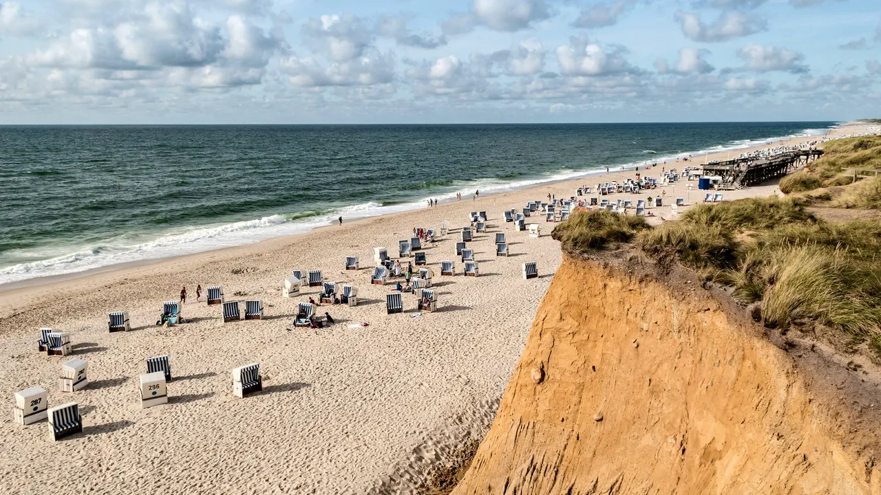
The beach and beach chairs below the Red Cliff
- Families60
- Getting around60
- Nature & outdoors58
Match
41
Every category weighted equally
- Beach & sun45
- Culture & arts36
- Food & nightlife38
- Family trip45
- Outdoors44
- Relax & unwind46
- Shopping & style41
- On a budget38
Sylt in twelve categories
Our verdict on each, scored 0 to 100 against the same fixed benchmark cities, so a score means the same thing on every page.
Beaches & swimming. Scores 55 out of 100.
Food & drink. Scores 52 out of 100.
Culture & sights. Scores 20 out of 100.
Nightlife. Scores 32 out of 100.
Nature & outdoors. Scores 58 out of 100.
Day trips. Scores 35 out of 100.
Good for families. Scores 60 out of 100.
Getting around. Scores 60 out of 100.
Shopping & style. Scores 40 out of 100.
Affordability. Scores 14 out of 100.
Live music & performing arts. Scores 12 out of 100.
Wellness & relaxation. Scores 58 out of 100.
Sylt category by category
Beaches & swimming
55The west coast is a single beach of pale sand roughly 40km long, backed by dunes and broken only by the beach accesses of each village. Westerland has the busy promenade stretch, Kampen and List feel wilder, and Hörnum at the southern tip has wide, quieter sand. Beach life follows a firm ritual of hired wicker beach chairs, windbreaks and long walks at the tideline, and it shapes the whole day from June to September.
The swimming itself is bracing. The North Sea is usually about 17-19°C at its warmest, the surf is often strong and rip currents are real, so people swim between the lifeguard flags. The eastern, Wadden Sea side has calmer, shallower water that warms faster, though it is muddier and tidal. A visitor who wants warm, easy swimming will find the sea more for looking at than for long dips.
Food & drink
52Eating on Sylt runs between two poles. At one end are fish counters and kiosks selling herring and shrimp rolls by the harbour in List and along the beach accesses, eaten standing in the wind. At the other is a surprisingly dense tier of gourmet restaurants in Keitum, Kampen, Rantum and Westerland, for a well-off clientele that comes back every summer. Oysters farmed in the Wadden Sea off List, North Sea shrimp, plaice and lamb from the salt meadows are the local specialities.
In between are thatched country inns serving Frisian cake and tea, and beach restaurants built into the dunes where a long lunch with a glass of white wine is part of the day. The range stays narrow, with little street food or variety beyond fish and North German cooking.
Culture & sights
20Sylt's heritage is quiet and small in scale. Keitum, the old captains' village on the east side, has lanes of thatched brick houses behind stone walls, the Sylt Museum and an old Frisian house museum, and the medieval church of St Severin on its rise above the mudflats. The Denghoog near Wenningstedt is a Stone Age passage grave you can climb down into, and the lighthouses at Kampen, Hörnum and List are landmarks of the island, Kampen's white tower with its broad black band the best known. A day covers it, and visitors come for the sea and the air rather than for sights.
Nightlife
32Going out on Sylt means Kampen in summer. Its short Strönwai, long nicknamed the Whisky Mile, is lined with champagne bars and terraces where a well-dressed crowd drinks late, and a few clubs nearby have been part of the island's jet-set legend for decades. Westerland adds pubs, a casino and a younger, more casual crowd, and beach bars hold sundowner parties on summer evenings.
Outside July and August, and away from those two places, the island is quiet early. It suits a glamorous evening out rather than a long run of club nights.
Nature & outdoors
58The landscape is open, flat and dominated by wind and tide. In the north near List the only shifting dunes in Germany move slowly across a protected heath, and the Ellenbogen peninsula runs out to the island's tip. Between Wenningstedt and Kampen the Red Cliff drops to the beach, and on the east side the Morsum Cliff exposes layered coloured sands. The east coast faces the Wadden Sea, a World Heritage mudflat where guided walks at low tide, seal trips and huge flocks of migrating birds are the main events.
A network of cycle paths runs the length of the island, and the west coast is one of Europe's best spots for windsurfing and kitesurfing. There is no relief beyond the dunes, and the weather can be raw.
Day trips
35Day trips mostly go by water. From Hörnum, excursion boats run to the neighbouring islands of Amrum and Föhr, with their own Frisian villages, and past the tiny Hallig islets whose farms sit on mounds against the floods. From List a car ferry crosses to the Danish island of Rømø, from which Tønder and the old cathedral town of Ribe are within reach by car. On the mainland, Husum, the grey harbour town of Theodor Storm, is a little over an hour by train across the causeway. Pleasant outings, but small ones.
Good for families
60Sylt is a classic family island in the German summer: endless sand for digging, dunes to run in and car-free cycle paths between villages. Families with small children often prefer the Wadden Sea side, where the water is shallow and calm, or Hörnum and Rantum, which are quieter than Westerland. The nature centre in List explains the tides and the North Sea with hands-on exhibits, mudflat walks and seal trips appeal to older children, and an indoor seawater pool in Westerland covers rainy days.
The limits are the cold water, the strong surf on the west coast, changeable weather and the lack of bigger attractions made for children.
Getting around
60The island has no road bridge. Trains cross the Hindenburg Causeway from the mainland, both regular passenger trains to Westerland and a car-carrying train from Niebüll, and a car ferry links List with Denmark. Once there, buses run the length of the island between the villages, and the cycle paths are the best way to move about, flat but often into a stiff headwind.
Westerland is easy to walk, while Kampen, Keitum and List are separate villages spread along an island almost 40km long. Many visitors bring a car, though summer traffic on the single main road and scarce parking make bikes and buses the calmer choice.
Shopping & style
40Kampen is the surprise. Its thatched houses hold branches of international luxury labels and fashion boutiques aimed at the island's wealthy summer visitors. Westerland's pedestrian Friedrichstraße has more everyday shops, and Keitum has galleries, ceramics and interiors shops in its old village lanes. Island-branded clothing, sea salt and local delicacies are the typical things to take home. It is boutique shopping in a few streets, not a destination for serious retail.
Affordability
14Sylt is one of the most expensive places in Germany to stay. Rented apartments and hotels in Kampen and Keitum charge luxury rates in summer, Westerland and Hörnum are only somewhat cheaper, and restaurants are priced for a well-off clientele. A visitors' tax is charged on top of accommodation, and arriving by car train adds to the bill. Buses, bakeries and fish kiosks keep everyday costs bearable, and shoulder-season stays are gentler, but a summer week here is a significant outlay.
Live music & performing arts
12Live performance on Sylt is occasional. Westerland has a small venue programme of cabaret, readings and touring acts, churches such as St Severin hold summer concerts, and beach bars put on live bands in the season. There is no theatre company, orchestra or regular music venue, and evenings out here are about dinner and drinks rather than a show.
Wellness & relaxation
58Sylt has been a seaside health resort since the nineteenth century, built on the idea that the salty, bracing North Sea air does you good. That tradition carries on in thalassotherapy, seawater pools and saunas, many with views over the dunes, and in a large number of hotel spas in Westerland, Kampen and Keitum. German sauna culture is strong here, and a hot sauna followed by a run into the cold sea is a local ritual even out of season.
The pace does the rest. Long walks on the beach, wind, thatched villages and early nights make the island deeply restful outside the busiest summer weeks, though there are no thermal springs.
Where to stay in Sylt
Westerland is the practical base for a first visit. The trains from the mainland arrive here, the town is easy to walk, and it has the promenade stretch of beach, the everyday shops of Friedrichstraße, an indoor seawater pool for wet days and a more casual crowd in the evenings. It suits anyone arriving without a car who wants things close at hand.
Kampen is where to stay for the island's glamorous side. Its thatched houses hold luxury boutiques, the Strönwai fills with late drinkers in summer, and the beach below the Red Cliff feels wilder. Keitum, on the calm Wadden Sea side, suits a quiet stay built around good dinners, galleries and walks past captains' houses to the mudflats. Both are among the costliest places to sleep on an expensive island.
Families and anyone after quiet sand tend to pick Hörnum or Rantum in the south, with wide beaches and a slower pace. Excursion boats to Amrum and Föhr also leave from Hörnum. List, in the far north, suits walkers and nature lovers, with the shifting dunes, the Ellenbogen and the harbour fish counters nearby. The island is almost 40km long, but buses and cycle paths link every village, so one base covers a whole stay without moving.
When should you go?
Pick a month to see what it is like. The climate figures are measured averages, not a forecast.
Sylt in July
Daytime high, °C
Rainfall in the month, mm
The whole year
Shaded against this destination’s own year: the deepest cell is its best month for that figure and the palest its weakest.
Temperature and rainfall are climate normals, averaged over the years shown. Sylt: 2009-2025 (sunshine 1991-2020, rainfall 1991-2020) normals, Westerland / Sylt (2.8 km from centre).
Before you go
| Measure | Sylt |
|---|---|
| Official language | German |
| Currency | Euro (EUR) |
| Sockets | CF230 V, 50 Hz |
| Driving side | Right |
| Time zone | UTC+1, UTC+2 in summer |
| Emergency number | 112 |
| Main airport | Westerland Sylt Airport (GWT)7 non-stop destinations |
| Public holidays this year | 10 days |
By the numbers
| Measure | Sylt |
|---|---|
| Population | 18,118 |
| People per km² | 316 |
| Swim season, months above 21 °C | None |
Compare Sylt with
Every comparison with a written verdict behind it.