New Zealand
Bay of Islands
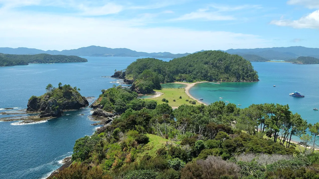
The lagoon of Motuarohia Island from the lookout
- Nature & outdoors77
- Beaches66
- Families56
Photo: Pseudopanax at English Wikipedia, CC BY 4.0, cropped
Match
42
Every category weighted equally
- Beach & sun46
- Culture & arts37
- Food & nightlife34
- Family trip48
- Outdoors49
- Relax & unwind47
- Shopping & style36
- On a budget41
Bay of Islands in twelve categories
Our verdict on each, scored 0 to 100 against the same fixed benchmark cities, so a score means the same thing on every page.
Beaches & swimming. Scores 66 out of 100.
Food & drink. Scores 38 out of 100.
Culture & sights. Scores 46 out of 100.
Nightlife. Scores 14 out of 100.
Nature & outdoors. Scores 77 out of 100.
Day trips. Scores 38 out of 100.
Good for families. Scores 56 out of 100.
Getting around. Scores 38 out of 100.
Shopping & style. Scores 20 out of 100.
Affordability. Scores 33 out of 100.
Live music & performing arts. Scores 22 out of 100.
Wellness & relaxation. Scores 50 out of 100.
Bay of Islands category by category
Beaches & swimming
66The bay is a drowned river valley full of sheltered coves, so the water is calm, clear and safe for most of the summer. The sea reaches about 21°C to 22°C in February and March and is pleasant from December to April, cool for the rest of the year. Paihia has a town beach on its waterfront, Russell's Long Beach is a short walk over the hill from the village, and the islands, Urupukapuka above all, have small white-sand bays reached by ferry or boat.
The finest beaches lie just north of the bay, at Matauri Bay, Tauranga Bay and the coves around the Cavalli coast, all a short drive from Kerikeri. Beach life is part of a stay here rather than the whole of it: most days mix a swim with a boat trip or a walk.
Food & drink
38Eating here is about what comes out of the water and off the orchards. Snapper, kingfish, green-lipped mussels and local oysters turn up on waterfront menus in Paihia and Russell, and fish and chips eaten on the sea wall is a fixture of the place. Kerikeri, set among citrus and avocado orchards, is the better base for food, with a Sunday farmers' market, cafés with serious coffee and a handful of small vineyards and chocolate and preserve makers on the roads around town.
The range is that of small towns: a few good restaurants, many casual ones, and little late or varied dining. Food is a pleasure of a stay here, not a reason to come.
Culture & sights
46This is where modern New Zealand began, and the history is the main reason to look beyond the water. The Waitangi Treaty Grounds, where the treaty between the Crown and Māori chiefs was signed in 1840, hold the carved meeting house Te Whare Rūnanga, a great ceremonial war canoe, the Treaty House and a museum that tells the story with care. Across the water, Russell was the first European settlement, a rough whaling port called Kororāreka, and keeps Christ Church, the country's oldest surviving church, and Pompallier Mission, a Catholic printing house.
In Kerikeri the Mission Station holds Kemp House and the Stone Store, the oldest wooden and stone buildings in the country, beside the river basin. It is a small set of sites, seen in two days, but each carries real weight.
Nightlife
14Evenings are quiet. Paihia has a few backpacker bars and waterfront pubs that fill up on summer nights, and Russell's historic hotel bar and waterfront are pleasant for a drink at sunset, but most places close early and there is no club scene. People here are up early for boats and fishing, and the night follows that rhythm.
Nature & outdoors
77The bay itself is the landscape: about 144 islands, sheltered inlets and headlands of pōhutukawa that flower red around Christmas. Sailing, sea kayaking and fishing are the natural way to spend a day, and bottlenose and common dolphins live in the bay all year, with orca and whales passing at times. Boats run out to Cape Brett and the Hole in the Rock, and the multi-day Cape Brett track crosses the peninsula to a lighthouse hut.
Inland, the walk from Paihia through mangroves to Haruru Falls, Rainbow Falls near Kerikeri and the kauri stands of Puketi Forest are easy outings. The Poor Knights Islands, one of the great temperate dive sites, are reached from Tutukaka to the south. There are no mountains, and much of the wider north is farmland.
Day trips
38The bay's own towns are close together, so Russell, Paihia and Kerikeri make easy half days from each other. Further out, the Hokianga harbour on the west coast, about an hour and a half away, has the old timber villages of Rawene, Opononi and Omapere and a strong Māori presence. Mangonui and Doubtless Bay to the north are about an hour by car, with an old waterfront and a famous fish shop tradition, and Whangārei, about an hour south, has a town basin, an art museum and falls on its edge.
The Kauri Museum at Matakohe is a long day. The far north's Cape Reinga and Ninety Mile Beach are a full-day coach trip, more landscape than places to visit.
Good for families
56Families come here for the kind of summer New Zealanders have themselves: calm beaches, camping grounds with cabins, rock pools and boats. Dolphin cruises and the trip out to the Hole in the Rock suit children well, the island beaches on Urupukapuka are sheltered and shallow, and kayaks are easy to hire in sheltered water. The cultural performance at the Waitangi Treaty Grounds holds children's attention better than most museums.
It is safe and relaxed, but there is nothing built for children beyond that: no zoo, aquarium or theme park, and rainy days are hard to fill. Most of the fun depends on settled summer weather.
Getting around
38Paihia is small and flat, with its wharf, waterfront and Waitangi all on foot, and a passenger ferry crosses to Russell in a few minutes. Island trips start from the same wharves. Beyond that, a car is the practical way to reach Kerikeri, the northern beaches and the west coast. Roads are quiet but winding, and public buses are few. Most visitors drive up from Auckland, about three and a half hours away, or fly to the small airport at Kerikeri and hire a car there.
Shopping & style
20Shopping is a small affair. Paihia's waterfront sells souvenirs, outdoor clothing and some Māori carving and pounamu greenstone, and Kerikeri has galleries, potters, woodturners and a few boutiques on its main street and the craft trail around town. It is pleasant to browse but not a reason to come.
Affordability
33In the summer season this is an expensive part of an expensive country. Waterfront rooms and lodges fill early around Christmas and January, eating out costs what it does in Auckland, and the boat trips, dolphin cruises and sailing that are the point of coming add up quickly. Camping grounds with cabins, backpacker hostels, self-catering cottages and a car let a visitor keep costs down, and the walks, beaches and the Paihia to Russell ferry cost little.
Live music & performing arts
22The performance worth attending is the Māori cultural show at the Waitangi Treaty Grounds, with haka and waiata in the carved meeting house, held by day and on some evenings. Kerikeri has a modest performing arts centre with touring music and theatre, and the Bay of Islands Jazz and Blues Festival is a long-standing part of the calendar. Beyond that, live music means a band in a pub on a summer weekend.
Wellness & relaxation
50The pace is the main remedy here: early mornings on still water, short drives, quiet evenings. The Ngāwhā hot springs, a Māori-owned geothermal site inland near Kaikohe, about half an hour from Kerikeri, have mineral pools long used for soaking. Around the bay, a few luxury lodges and day spas offer massage and treatments, and yoga and retreat stays are scattered across the hills. There is no bathing tradition in the towns themselves, so a visitor who wants more than calm needs to seek it out.
Where to stay in Bay of Islands
Paihia is the practical base for a first visit. It is small and flat, with the wharf, the waterfront and the Waitangi Treaty Grounds all within walking distance. Boats to the islands, dolphin cruises and trips to the Hole in the Rock all leave from its front. It has the widest choice of places to stay, from backpacker hostels to waterfront motels, and what little evening life the bay has. It suits families, younger travellers and anyone without a car.
Russell is a few minutes across the water by passenger ferry and is the quieter choice. It is an old whaling village with the country's oldest surviving church, a waterfront for a drink at sunset, and Long Beach a short walk over the hill. It suits couples and anyone after a calm stay, and Paihia's boats are close enough for day trips on the water.
Kerikeri sits inland among citrus and avocado orchards. It is the base for food and for exploring by car, with its Sunday market, good cafés and the old Mission Station by the river. The beaches at Matauri Bay and Tauranga Bay are a short drive north, and the airport is close by. The three towns are near each other, so one base is enough for most trips. Kerikeri needs a car, but you can manage in Paihia and Russell without one.
When should you go?
Pick a month to see what it is like. The climate figures are measured averages, not a forecast.
Bay of Islands in July
Daytime high, °C
Rainfall in the month, mm
The whole year
Shaded against this destination’s own year: the deepest cell is its best month for that figure and the palest its weakest.
Where the figures come from
Bay of Islands's temperatures are measured 78 km from the centre, at Kaitaia.
Bay of Islands has no rain gauge within 25 km of the centre, so its rainfall comes from a gridded climate dataset read at the destination rather than from a gauge further away.
Temperature and rainfall are climate normals, averaged over the years shown. Bay of Islands: 1991-2020 normals, Kaitaia (77.6 km from centre).
Before you go
| Measure | Bay of Islands |
|---|---|
| Official language | English, New Zealand Sign Language, Māori |
| Currency | New Zealand Dollar (NZD) |
| Sockets | I230 V, 50 Hz |
| Driving side | Left |
| Time zone | UTC+12, UTC+13 in summer |
| Emergency number | 111 |
| Main airport | Kerikeri Airport (KKE)1 non-stop destination |
| Public holidays this year | 12 days |
By the numbers
| Measure | Bay of Islands |
|---|---|
| Swim season, months above 21 °C | 1 month |
Compare Bay of Islands with
Every comparison with a written verdict behind it.