Colombia
Salento
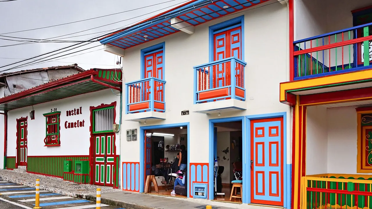
Brightly painted houses with balconies on Calle 5
- Nature & outdoors82
- Affordable cities78
- Families55
Photo: Bernard Gagnon, CC BY-SA 4.0, cropped
Match
37
Every category weighted equally
- Beach & sun38
- Culture & arts33
- Food & nightlife29
- Family trip44
- Outdoors46
- Relax & unwind39
- Shopping & style33
- On a budget42
Salento in twelve categories
Our verdict on each, scored 0 to 100 against the same fixed benchmark cities, so a score means the same thing on every page.
Beaches & swimming. Scores 3 out of 100.
Food & drink. Scores 28 out of 100.
Culture & sights. Scores 20 out of 100.
Nightlife. Scores 14 out of 100.
Nature & outdoors. Scores 82 out of 100.
Day trips. Scores 45 out of 100.
Good for families. Scores 55 out of 100.
Getting around. Scores 40 out of 100.
Shopping & style. Scores 27 out of 100.
Affordability. Scores 78 out of 100.
Live music & performing arts. Scores 7 out of 100.
Wellness & relaxation. Scores 45 out of 100.
Salento category by category
Beaches & swimming
3There is no beach life here. Salento sits high in the Andean coffee country, a long way from either coast, and the rivers that run off the mountains are cold, fast and rocky rather than places to swim. The nearest thing to a swim is a pool at a finca hotel or the water attractions at the theme parks down in the valley around Armenia. Anyone who wants the sea should plan it as a separate leg of the trip, on the Caribbean coast.
Food & drink
28Eating in Salento is simple and centres on one dish: river trout from the local farms, served fried, grilled or in sauce on a huge crisp patacón, the flattened fried plantain. Around the plaza and along the main street there are cafés, bakeries and family places serving hearty set lunches of beans, rice, meat and soup, with arepas and fresh fruit juices in between.
The real draw is coffee. The fincas on the hills around town grow it, and a visitor can walk out to see it picked, roasted and brewed, then drink it at the source. Beyond that, the range is narrow and the tourist menus repeat themselves, so this is a place for good coffee and a plate of trout rather than for serious eating.
Culture & sights
20Salento's sight is the town itself. The streets around the main square, and above all Calle Real, are lined with one- and two-storey houses in the region's traditional bahareque building, timber and earth walls painted in bright colours, with carved wooden balconies, doors and window frames. The town lies within the Coffee Cultural Landscape of Colombia, recognised by UNESCO, and at the top of a long stairway the Alto de la Cruz viewpoint looks out over the green valleys.
That is most of it. There is a plain church on the plaza and little in the way of museums, so an hour or two covers the town, and the coffee farms add the region's working heritage.
Nightlife
14Evenings are low-key. A few bars around the plaza play salsa and vallenato and fill up with backpackers and weekending Colombians. The most memorable night out is a game of tejo, the local sport, played with beer in rustic halls: players throw heavy metal discs at clay targets packed with small gunpowder charges that go off with a bang. Most visitors are up early for hikes, so on weeknights the town is quiet well before midnight. It gets livelier on the long weekends when Colombians come up from the cities.
Nature & outdoors
82This is why people come. Half an hour up the road by jeep, the Cocora Valley fills with Quindío wax palms, Colombia's national tree, rising up to 60m above green pastures and misty ridges. The classic loop climbs through cloud forest, over swaying plank bridges and past hummingbird feeders before dropping back among the palms, a solid half-day walk.
Beyond it the land climbs into Los Nevados National Park, where guided treks of several days cross páramo of frailejón plants towards glaciated volcanoes above 4,500m. Closer in there are horse rides, walks down to coffee farms along the Quindío river and good birdwatching. The climate is mild but wet, with heavy rain likely in the two rainy seasons and mist on most afternoons.
Day trips
45The coffee region is dotted with small towns, and the best of them make easy outings. Filandia, about 45 minutes away, is a quieter version of Salento with its own painted balconies and a wooden lookout tower over the hills. Buenavista, perched on a ridge, and Circasia and Montenegro add more of the same countryside. Armenia, under an hour away, has a good museum of the pre-Columbian Quimbaya goldwork, and Pereira about an hour off is the region's livelier city.
It is a pleasant circuit but a repetitive one: the towns share the same architecture and coffee culture, and nothing within reach is a major heritage site in its own right.
Good for families
55Salento works well for families who like the outdoors. The town is small and easy to manage, riding in the back of an open jeep is a treat in itself, and children enjoy horse rides, the hummingbirds in the cloud forest and seeing coffee picked on a farm. The Cocora loop is long and muddy for small legs, though a shorter walk among the palms is easy.
The region's two theme parks lie about an hour away: the Parque del Café, with rides and a cable car over coffee hills, and Panaca, an agricultural park built around farm animals. Steep streets and frequent rain are the main nuisances.
Getting around
40Salento itself is small enough to cross on foot in a few minutes. Calle Real, the plaza and the guesthouses are all close together, though some streets and the stairway up to the viewpoint climb steeply. Several coffee farms are a walk away along country lanes.
Beyond that there is no network as such. The old Willys jeeps that gather on the plaza are the way to the Cocora Valley, about half an hour up the road, and they set off when they have enough passengers rather than to a fixed plan. Regional buses run down to Armenia and Pereira, about an hour away, and reaching most of the other coffee towns usually means changing there. It all works without a car, but it takes patience: there can be waits, the roads are winding, and on long weekends the jeeps and buses fill up with Colombian visitors. Travellers who want to cover a lot of the region in a few days often hire a driver.
Shopping & style
27Calle Real is lined with craft shops selling woven bags, ponchos, carved wood, hand-painted signs and jewellery, alongside more ordinary souvenirs. Bags of beans from the surrounding farms make the best thing to take home. That is the whole of it: no fashion, no markets of note, and anything more needs a trip to the malls of Armenia or Pereira.
Affordability
78Salento is inexpensive for a visitor. Hostels and simple guesthouses are plentiful, a filling set lunch costs little, and the jeeps and buses are cheap. The town is dearer than the ordinary farming towns around it, since it lives on visitors, and the boutique finca hotels and guided treks into the high mountains add up. Still, a comfortable stay here costs a fraction of one in Western Europe or North America.
Live music & performing arts
7There is no theatre or concert life in Salento. Music means a guitar in a café, a band in a bar on a weekend or the parades and concerts of the town's annual festivities. For anything more, the nearest stages are in Pereira and Armenia.
Wellness & relaxation
45What makes Salento restful is its pace. Stay on a coffee finca outside town and the mornings bring mist over the hills, birdsong and a cup brewed from beans grown on the slope. A few places offer yoga and massage. The town itself fills up with day-trippers at weekends and on long weekends, so the quiet is on its edges.
Salento has no spa culture of its own. For a day of soaking, the hot springs above Santa Rosa de Cabal are about two hours away, with thermal pools beneath tall waterfalls.
When should you go?
Pick a month to see what it is like. The climate figures are measured averages, not a forecast.
Salento in July
Daytime high, °C
Rainfall in the month, mm
The whole year
Shaded against this city’s own year: the deepest cell is its best month for that figure and the palest its weakest.
Where the figures come from
Salento has no weather station within reach, so its figures come from a gridded climate model rather than a measured record, and read a broad area rather than the city itself.
Temperature and rainfall are climate normals, averaged over the years shown. Salento: 2001-2020 normals, NASA POWER reanalysis grid, no weather station within 90 km.
Before you go
| Measure | Salento |
|---|---|
| Official language | Spanish |
| Currency | Colombian Peso (COP) |
| Sockets | AB110 V, 60 Hz |
| Driving side | Right |
| Time zone | UTC-5 |
| Emergency number | 123 |
| Elevation | 1,895 m |
| Main airport | El Eden Airport (AXM)30 km from centre2 non-stop destinations |
| Public holidays this year | 19 days |
By the numbers
| Measure | Salento |
|---|---|
| City population | 7,578 |
| People per km² | 20 |
| Museums within 10 km | 0 |
| UNESCO World Heritage sites within 50 km | 1 |
Compare Salento with
Every comparison with a written verdict behind it.