Guatemala
Antigua Guatemala
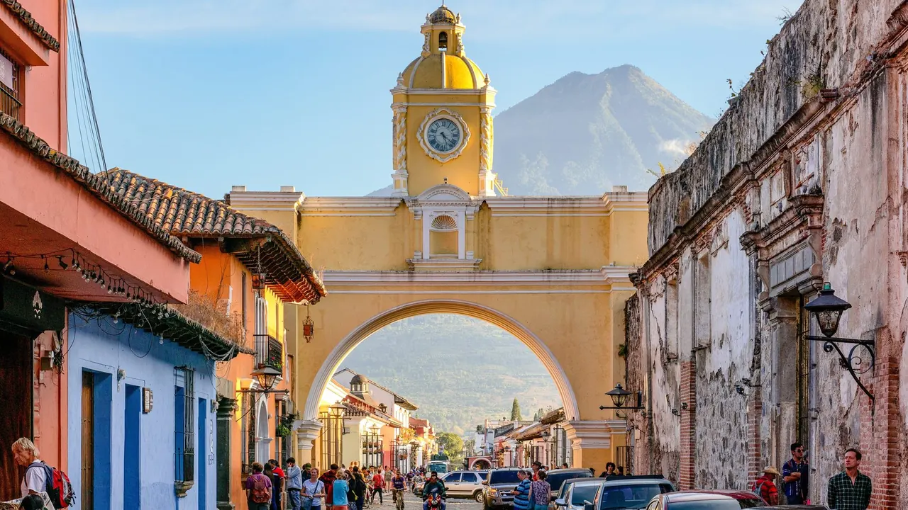
The Santa Catalina arch below Volcan de Agua
- Nature & outdoors78
- Culture & sights68
- Affordable cities67
Photo: Chad Davis, CC BY-SA 2.0, cropped
Match
47
Every category weighted equally
- Beach & sun44
- Culture & arts50
- Food & nightlife45
- Family trip48
- Outdoors52
- Relax & unwind46
- Shopping & style47
- On a budget49
Antigua Guatemala in twelve categories
Our verdict on each, scored 0 to 100 against the same fixed benchmark cities, so a score means the same thing on every page.
Beaches & swimming. Scores 6 out of 100.
Food & drink. Scores 48 out of 100.
Culture & sights. Scores 68 out of 100.
Nightlife. Scores 34 out of 100.
Nature & outdoors. Scores 78 out of 100.
Day trips. Scores 55 out of 100.
Good for families. Scores 38 out of 100.
Getting around. Scores 60 out of 100.
Shopping & style. Scores 45 out of 100.
Affordability. Scores 67 out of 100.
Live music & performing arts. Scores 22 out of 100.
Wellness & relaxation. Scores 42 out of 100.
Antigua Guatemala category by category
Beaches & swimming
6Antigua sits in a highland valley at about 1,500m, and there is no swimming within an hour. The nearest coast is the Pacific shore around Monterrico, roughly two hours away by shuttle. It has warm water, often near 28°C, but the sand is black and volcanic, the surf is heavy and the currents are strong, so it suits an overnight stay more than a swim. In town, swimming means a hotel pool.
Food & drink
48For its size Antigua eats well, mostly because the coffee is grown on the volcano slopes around town. You can drink it in courtyard cafés or follow it from bush to cup on a farm tour. Guatemalan cooking shows up in rich stews such as pepián and jocón, in tamales and in chuchitos sold from stalls. Cacao has a long history here too, and chocolate makers sell bars and run tastings.
The central market near the bus terminal shows the everyday side of things, with comedores serving set lunches beside the produce stands. The restaurants around the central park are aimed at visitors and can be ordinary. Fine dining is limited, and the range runs out after a few days.
Culture & sights
68Antigua was the Spanish colonial capital of Central America until the earthquakes of 1773, after which the capital moved and much of the city was left standing in ruins. The result is a grid of low, colourful houses on cobbled streets, laid out in the 16th century, with roofless churches and convents on almost every other block. Inside the ruined cloisters of Capuchinas, San Francisco, Santa Clara and the cathedral, trees grow through broken vaults.
The yellow Santa Catalina arch, the restored façade of La Merced and the arcaded central park are the town's best-known images. The former Santo Domingo monastery holds several small museums. It is a place for slow walking rather than for big collections, and two or three days cover it well.
Nightlife
34Evenings centre on a few blocks near the central park and the Santa Catalina arch. There are rooftop bars with volcano views, candlelit mezcal and craft-beer bars hidden behind colonial doorways, and a couple of salsa spots popular with language students and backpackers. It is friendly and easy to fall into, but small, and the town winds down early, with most places closing well before the small hours. Weekends bring visitors up from the capital and are livelier.
Nature & outdoors
78Antigua is ringed by three volcanoes, and the outdoors here means climbing them. Agua's symmetrical cone fills the view from the town's streets. Acatenango is the classic overnight hike: a steep climb to a camp near 3,500m with a view across to Fuego, one of the most active volcanoes in the region, often lighting up the night with lava. Pacaya is an easier half-day walk over black lava fields.
Closer to town, a short walk up Cerro de la Cruz gives the standard view over the grid. Trails also run through the coffee farms, cloud forest and mountain-bike routes in the hills around. Mornings are clearest. The rainy season, roughly May to October, brings afternoon storms and cloud that hides the peaks.
Day trips
55The valley villages are the easiest outings, a short tuk-tuk or chicken-bus ride away. San Antonio Aguas Calientes is known for backstrap weaving, Ciudad Vieja was the site of an earlier capital, and San Juan del Obispo has a bishop's palace looking over the valley. Guatemala City, about an hour away, has the national archaeology museum and the Ixchel textile museum.
The Kaqchikel Maya ruins of Iximché are about an hour and a half west. Lake Atitlán, with its volcano-ringed shore and lakeside villages, and the Thursday and Sunday market at Chichicastenango are both a long day of two and a half hours or more each way, and many travellers stay overnight. Tikal is a flight away.
Good for families
38Antigua is small and slow, and families find it calm to manage, but almost nothing here is made for children. The cobbles and narrow, broken pavements are hard work with a pushchair. The best of it for children is hands-on: chocolate-making workshops, coffee-farm visits, horse rides, and the Pacaya volcano walk, which suits school-age children. Ruins with courtyards to roam help too. Younger children may tire of a town whose appeal is architecture and cafés. Hotels with gardens or pools make it easier.
Getting around
60The historic centre is a compact grid of about a dozen blocks each way, and almost everything a visitor wants is within a 15-minute walk. The volcanoes make good landmarks, so it is hard to get lost. Walking is the main way around, though the large, uneven cobbles and narrow pavements call for sensible shoes, and they are tiring for anyone unsteady on their feet.
Tuk-tuks cover the short hops. Brightly painted chicken buses run to the valley villages, and tourist shuttles handle the airport, the lake and the capital. Nobody needs a car, and traffic in the capital makes driving there one to avoid.
Shopping & style
45Shopping here means Guatemalan crafts, and they are good. Handwoven huipiles and textiles from the highland villages, jade carving, ceramics, embroidered bags and woven belts fill the craft market beside the main bus terminal and the shops along the streets near the arch. Local coffee and chocolate make easy things to carry home. Design boutiques in colonial courtyards sell more refined versions of the same crafts. There is no fashion or luxury shopping, and quality varies at the market stalls, so it pays to look closely and bargain.
Affordability
67Antigua is the most expensive place in Guatemala, and it costs more than the national reputation suggests. Boutique hotels in restored colonial houses and the restaurants around the central park charge close to Western rates. Still, a visitor watching their spending does well. Guesthouses and hostels are plentiful, comedor lunches and street snacks cost little, tuk-tuks and chicken buses are cheap, and the ruined churches charge modest entry fees. Guided volcano hikes and shuttles add up but are fair for what they include.
Live music & performing arts
22Formal performing arts are thin. Marimba music, the national instrument's sound, turns up in the central park and at some restaurants. Bars host local bands and salsa nights, and concerts are sometimes staged in ruined cloisters or at the cultural centres. There is no theatre or concert season to plan a trip around. The town's great spectacle is the Holy Week processions, with brass bands and sawdust carpets laid in the streets, which belong more to faith and tradition than to the stage.
Wellness & relaxation
42Antigua has no bathing culture of its own, but it is an easy place to slow down. The pace is unhurried, cars are few in the evening, and many hotels are built around quiet garden courtyards with fountains and views of the volcanoes. Yoga studios and massage rooms are common, and several boutique hotels have proper spas, some using local coffee and cacao in their treatments. Traditional Maya sweat baths, temazcales, are offered here and there. Church bells and fireworks for saints' days can break the calm early in the morning.
When should you go?
Pick a month to see what it is like. The climate figures are measured averages, not a forecast.
Antigua Guatemala in July
Daytime high, °C
Rainfall in the month, mm
The whole year
Shaded against this city’s own year: the deepest cell is its best month for that figure and the palest its weakest.
Where the figures come from
Antigua Guatemala has no rain gauge within 25 km of the centre, so its rainfall comes from a gridded climate dataset read at the city rather than from a gauge further away.
Temperature and rainfall are climate normals, averaged over the years shown. Antigua Guatemala: 1998-2020 (rainfall 1991-2020) normals, Guatemala Aeropuertola Aurora (23.5 km from centre).
Before you go
| Measure | Antigua Guatemala |
|---|---|
| Official language | Spanish |
| Currency | Quetzal (GTQ) |
| Sockets | AB120 V, 60 Hz |
| Driving side | Right |
| Time zone | UTC-6 |
| Emergency number | Police 110/120, ambulance 128, fire 123 |
| Elevation | 1,582 m |
| Main airport | La Aurora International Airport (GUA)22 km from centre19 non-stop destinations |
| Public holidays this year | 13 days |
By the numbers
| Measure | Antigua Guatemala |
|---|---|
| City population | 59,091 |
| Museums within 10 km | 2 |
| UNESCO World Heritage sites within 50 km | 1 |
Compare Antigua Guatemala with
Every comparison with a written verdict behind it.