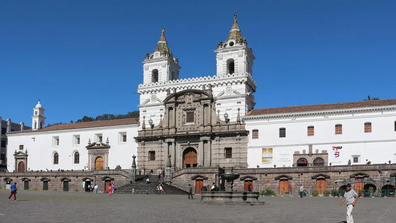
Photos: Quito by Bernard Gagnon, CC BY-SA 3.0, cropped.
La Paz or Quito?
Our verdict in twelve categories, each scored against the same fixed benchmark cities, and the climate month by month, so you can choose for your trip.
Choose La Paz for
- prices
- shopping
La Paz suits travellers who want the Andes at their most raw and who are counting every coin. The city is cheaper day to day, its street life of cholitas, ritual markets and cable cars over a canyon is unlike anywhere else, and the mountains on its doorstep reach glacier and six-thousand-metre height. In return it asks more of the body: the altitude is higher, the colonial sights are fewer and there is little to rest on.
Choose Quito for
- wellness
- culture and sights
- families
Quito is the easier and richer all-round choice, especially for a first trip to the Andes or a trip with children. Its gilded colonial centre is among the finest in the Americas, the air is a little kinder, and markets, the equator line, cloud forest and hot springs all lie within an easy day. It also works well as the starting point for the Galápagos or the coast.
Scoreboard
Twelve categories on one fixed scale from 0 to 100. The shaded stretch is the gap between the two.
Your match
Pick a travel style or drag the sliders, and both match scores follow your weighting.
Wins on prices and shopping with your weighting.
Wins on wellness and culture and sights with your weighting.
What matters to you?
Category by category
What the scores mean for a trip.
Beaches & swimming
Neither city has any beach life. Both sit high in the Andes, and the only water near La Paz is Lake Titicaca, too cold for anything but boat trips.
Quito at least has warm municipal pools in the valleys below town, and it is the usual starting point for a flight to the Pacific coast or the Galápagos. From La Paz, sand means a separate leg into Peru or Chile.
Food & drink
The two kitchens are on a similar level and share a liking for potatoes, markets and set lunches, but they feel different. La Paz eats on the street from breakfast onwards: salteñas mid-morning, hot api at dawn, anticucho grills at night, and markets selling a startling range of potatoes. Tarija wine and singani are its drinks, though the altitude can blunt the appetite at first.
Quito's highland cooking runs to roast pork, locro soup and sugared empanadas, eaten in the Mercado Central food courts. Its particular strength is Ecuadorian cacao and coffee, and on a chilly evening the hot canelazo punch.
Culture & sights
Quito is the stronger sightseeing city by a wide margin. Its old town was one of the first UNESCO World Heritage listings and remains a large, barely altered grid of churches and convents, from the gold-leafed La Compañía to the San Francisco monastery and the climbable towers of the Basílica del Voto Nacional. Casa del Alabado and Guayasamín's Capilla del Hombre add serious museums.
La Paz has a smaller colonial heart, led by the mestizo baroque front of San Francisco and the short lane of Calle Jaén. Its interest lies more in living culture: the Witches' Market, cholitas in bowler hats, the cholet mansions of El Alto and the view of the whole city from the cable cars.
Nightlife
Neither is a big night out, and the two are close. La Paz is quieter and more bar-based, with small craft-beer and cocktail places in Sopocachi and traveller bars near Sagárnaga; the cold and the altitude send most people to bed early.
Quito has more dancing, with salsa clubs and packed bars around Plaza Foch in La Mariscal from Thursday to Saturday, and La Ronda in the old town for a gentler evening stroll.
Nature & outdoors
Both cities have outstanding mountain settings, so the choice is about what kind. La Paz is the more extreme: a canyon city under Illimani, with Huayna Potosí for climbers, the Death Road bike descent into cloud forest, and the eroded spires of the Valle de la Luna close by.
Quito offers a gentler start and more variety. The TelefériQo lifts walkers to the páramo of Pichincha, Cotopaxi's glacier and high plains are two hours south, and the Mindo cloud forest is one of the world's great places for birdwatching.
Day trips
Quito has more good days out within easy reach. Otavalo's huge Indigenous market and the weaving villages lie about two hours north, the equator monument is under an hour away, and Mindo and the hot springs of Papallacta make two quite different further outings.
La Paz has one essential excursion, the pre-Inca ruins of Tiwanaku, and the busy markets of El Alto just above the city. Lake Titicaca, Isla del Sol and the warm Yungas towns are better done with a night away.
Good for families
Quito is the more workable city with children, though neither is easy. Its altitude is lower, and it has real treats: standing astride the equator, the TelefériQo, the hands-on Yaku water museum and the pedal boats and playgrounds of Parque La Carolina.
La Paz is genuinely hard on small children. Arrival at around 4,000m in El Alto carries a real risk of altitude sickness, the streets are steep and traffic is heavy, and beyond the cable cars and the Mallasa zoo there is little made for them. It suits families with hardy teenagers better.
Getting around
The two are equally manageable, by very different means. La Paz moves by air: the Mi Teleférico cable-car network links the centre, the southern suburbs and El Alto, backed only by minibuses and cheap taxis.
Quito, long and thin along its valley, relies on a north-south metro line and bus corridors, crowded at rush hour and worked by pickpockets. In both, the walkable centres are steep and breathless at first, and taxis are the easy option after dark.
Shopping & style
Both are craft cities rather than fashion cities, and they are roughly level. La Paz has the denser market experience: the stall-lined lanes of Sagárnaga for alpaca, weaving and silver, the Witches' Market, and El Alto's sprawling 16 de Julio fair.
Quito's best buys are more particular to Ecuador, notably genuine toquilla-straw Panama hats, bean-to-bar chocolate and tagua-nut carvings, though serious craft buyers wait for Otavalo.
Affordability
Both are inexpensive, but La Paz is the cheaper of the two. Everyday meals, cable-car rides, taxis and good central hotels cost very little, and the main spending is on a reputable operator for the Death Road or a climb.
Quito's daily costs are also low, especially in old-town guesthouses, but international hotels in the north and volcano excursions add up faster. A Galápagos trip from Quito is a large extra expense.
Live music & performing arts
In La Paz the best performances happen in the street and in folk peñas, while Quito's centre is a gilded nineteenth-century theatre. In La Paz, panpipes, charangos and dancers in morenada and diablada costume fill the peñas, and once a year the Gran Poder festival turns whole streets into a parade of brass bands and dancers.
Quito's Teatro Nacional Sucre gives it the grander formal evening, with opera and the national symphony. Its folk ballet companies and the occasional baroque concert in an old-town church round out a programme that is also modest overall.
Wellness & relaxation
Quito is clearly the better place to unwind. The steaming thermal pools of Papallacta, set in misty páramo, are about an hour and a half away and form a real weekend spa culture, with simpler public pools at El Tingo closer in.
La Paz offers little rest. Its centre is loud and fume-filled, the higher altitude disturbs sleep for the first nights, and relaxation mostly means coca tea, an early night and the leafy streets of Sopocachi. The Urmiri hot springs are the nearest escape.
When should you go?
Pick your month. The climate figures are measured averages, not a forecast.
La Paz in July
Quito in July
Daytime high, °C
Rainfall in the month, mm
Where the figures come from
La Paz has no weather station within reach, so its figures come from a gridded climate model rather than a measured record, and read a broad area rather than the city itself.
Quito's station stands 208 m above the city centre, so the centre is likely a little warmer than the figures say.
Temperature and rainfall are climate normals, averaged over the years shown. La Paz: 2001-2020 normals, NASA POWER reanalysis grid, no weather station within 90 km. Quito: 1961-1990 normals, Izobamba-Santa Catalina (16.8 km from centre).
Neither city has seasons of heat and cold in the usual sense; both stay cool all year, and the rain decides the best time. La Paz is the colder of the two, with daytime highs around 14°C in every month and frosty nights. Its dry season runs from May to September, the clearest time for the mountains and for walking the steep streets, while December to February are the wettest months, with about 136mm falling in January.
Quito is milder, at about 18°C by day all year, and wetter for longer. Rain builds from February to May, peaking at around 195mm in April, and returns from October. June to August is the dry spell, with only about 32mm in July and the most sunshine of the year. For a single trip covering both, June to August catches each at its driest.
Which traveller are you?
On a culture and arts trip, Quito rewards the longer stay. La Paz's formal sights fill a day or two, after which its interest lies in watching the streets, while Quito's old town and museums can carry several unhurried days on foot.
For a trip on a tight budget, La Paz makes the money go furthest. Daily life costs so little that a modest budget still buys comfort, leaving room for one big guided adventure. Quito is cheap too, but costs climb faster once you step beyond the basics.
On a family trip with children, Quito is much the safer base. La Paz has higher altitude, real health risks for small children and little to fill the days. Quito lets families keep to short, gentle outings and move on easily to the cloud forest or coast.
Before you go
| Measure | La Paz | Quito |
|---|---|---|
| Official language | Spanish, Aymara, Quechua, Guarani | Spanish, Shuar, Northern Quichua |
| Currency | Boliviano (BOB) | US Dollar (USD) |
| Sockets | AC50 Hz | AB120 V, 60 Hz |
| Driving side | Right | Right |
| Time zone | UTC-4 | UTC-5 |
| Emergency number | 911 | 911 |
| Elevation | 3,640 m | 2,850 m |
| Main airport | El Alto International Airport (LPB)6 km from centre12 non-stop destinations | Mariscal Sucre International Airport (UIO)20 km from centre22 non-stop destinations |
| Public holidays this year | 12 days | 11 days |
By the numbers
| Measure | La Paz | Quito |
|---|---|---|
| City population | 755,732 | 1,763,275 |
| People per km² | 1,601 | 4,735 |
| Museums within 10 km | 21 | 16 |
| UNESCO World Heritage sites within 50 km | 1 | 2 |
Where else could you go?
Every comparison below shares a destination with this one, so you can follow La Paz or Quito somewhere new.