Mexico
Puerto Vallarta
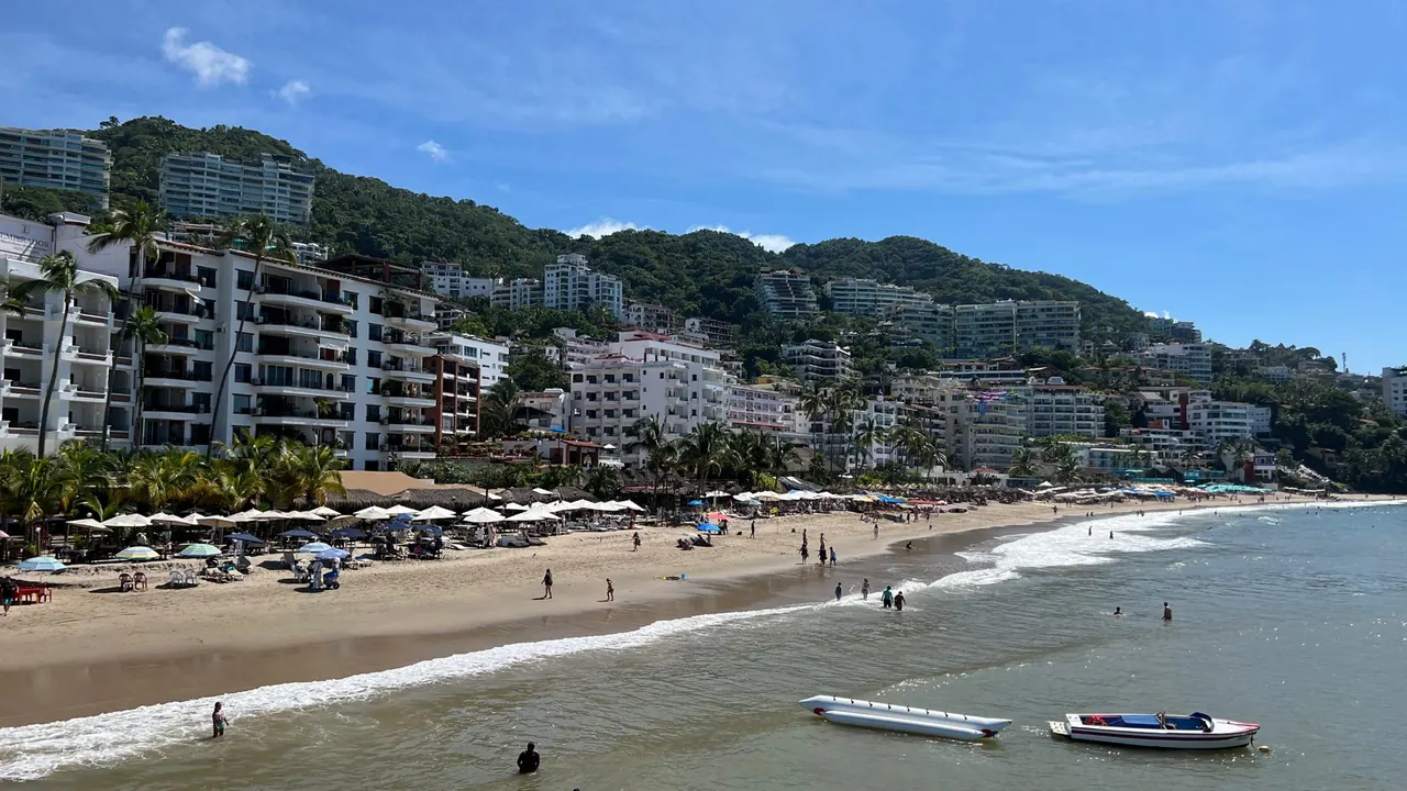
Playa de los Muertos below the green hills
- Beaches85
- Nature & outdoors76
- Nightlife66
Photo: RL0919, CC BY-SA 4.0, cropped
Match
56
Every category weighted equally
- Beach & sun62
- Culture & arts48
- Food & nightlife53
- Family trip59
- Outdoors60
- Relax & unwind59
- Shopping & style51
- On a budget56
Puerto Vallarta in twelve categories
Our verdict on each, scored 0 to 100 against the same fixed benchmark cities, so a score means the same thing on every page.
Beaches & swimming. Scores 85 out of 100.
Food & drink. Scores 62 out of 100.
Culture & sights. Scores 28 out of 100.
Nightlife. Scores 66 out of 100.
Nature & outdoors. Scores 76 out of 100.
Day trips. Scores 55 out of 100.
Good for families. Scores 65 out of 100.
Getting around. Scores 45 out of 100.
Shopping & style. Scores 42 out of 100.
Affordability. Scores 60 out of 100.
Live music & performing arts. Scores 32 out of 100.
Wellness & relaxation. Scores 52 out of 100.
Puerto Vallarta category by category
Beaches & swimming
85Puerto Vallarta sits on Banderas Bay, one of the largest bays in Mexico, and the beach is the centre of most stays. In town, Playa Los Muertos in the Zona Romántica is the busiest stretch, lined with loungers and seafood grills, while Conchas Chinas just south has rocky pools and calmer corners. Further south the mountains drop straight into the sea, and small coves such as Mismaloya, Las Animas and Yelapa are reached by road or water taxi.
The water stays around 26°C in winter and reaches 30°C in late summer. The bay is generally gentle, especially on the flat, wide sands of Nuevo Vallarta to the north. The surf beaches of the Riviera Nayarit, around Punta de Mita and Sayulita, are within about an hour. The sand is coarser and golden rather than powder white, and the summer rains can cloud the sea.
Food & drink
62Eating well is one of the pleasures of a stay. The local strength is Pacific seafood: pescado zarandeado grilled over wood on the beach, fish on a stick sold along the sand, ceviche and fiery aguachile of raw shrimp. In the evening, taco stands and carts appear on street corners in the centre and the Zona Romántica, serving birria, al pastor and marlin tacos. The small mountain spirit raicilla, a relative of mezcal, is worth trying.
For a town of its size there is also a broad restaurant tier, from palapa seafood places to chef-run dining rooms in the hills, many of them with sea views. Along the Malecón and in the hotel strips, much of the food is safe, pricier tourist fare. The best meals usually come from the simplest places a few streets back from the water.
Culture & sights
28Puerto Vallarta is more of an attractive old fishing town than a place for sightseeing. The best things to see are the whitewashed, red-tiled streets climbing the hill behind the centre, the Church of Our Lady of Guadalupe with its unusual crown-topped tower, and the seafront Malecón. The Malecón is lined with bronze sculptures and looks across to the setting sun.
The small Naval Museum, the Cuale river island with its little archaeological museum, and the galleries of the old centre fill an afternoon. Beyond that, a visitor looking for museums, monuments or deep history will find little, and that is not why people come.
Nightlife
66Puerto Vallarta goes out later and louder than most beach towns. Along the Malecón, open-fronted dance clubs and bars face the sea and fill up after midnight, especially in the winter high season, during Semana Santa and over Christmas and New Year, when Mexican visitors arrive in numbers. The Zona Romántica, south of the Cuale river, is quieter in style but just as late. It has rooftop bars, mezcal bars, beach clubs and one of the largest and most established gay scenes in Latin America.
The mood is easygoing and made for people on vacation rather than cutting-edge, and it thins out noticeably in the hot, rainy summer. Nuevo Vallarta and the resort strips to the north are much quieter at night.
Nature & outdoors
76The setting is the real draw. The Sierra Madre rises steeply behind the town in green, jungle-covered ridges, so the landscape is tropical forest meeting the sea. From December to March humpback whales calve in Banderas Bay and are easy to see from boats, sometimes from the shore. Boats also run to the rock arches of Los Arcos for snorkelling and to the Marietas Islands, a protected seabird and reef area off Punta de Mita.
On land there are coastal trails along the roadless south shore towards Las Animas and Yelapa, a large botanical garden in the hills, river canyons, and zip-lines and mountain biking in the jungle. Surfers head north to Punta de Mita and Sayulita, and turtles nest on the bay's beaches in summer and autumn. The dry winter months are best, as summer heat, humidity and rain make longer outings hard work.
Day trips
55Most day trips go along the coast. To the north, Bucerías, the surf village of Sayulita and quieter San Pancho are within about an hour. Each has a small plaza, artisan shops and a different beach-town character. To the south, Yelapa can only be reached by boat. It is a village of palm-roofed houses and a waterfall walk.
Inland, a winding road of about an hour and a half climbs to San Sebastián del Oeste, a former silver-mining town with cobbled streets, an old hacienda and coffee farms in the pines. The mountain towns of Mascota and Talpa are a longer day out. Guadalajara and the tequila country are too far for a comfortable return trip.
Good for families
65Puerto Vallarta is easy with children if the plan centres on the beach. The bay is warm and generally gentle, and the long, flat sands of Nuevo Vallarta to the north are the calmest. Many resorts there are built around families, with shallow pools and kids' clubs. Winter whale-watching trips, boat rides to snorkelling spots, a small zoo in the jungle at Mismaloya, water parks and turtle releases in nesting season give plenty to fill the days.
Mexican culture is warm towards children, and evening walks on the Malecón with street performers and ice cream are part of the routine. Cobbled, steep streets are hard with pushchairs, and the summer heat and humidity are tiring for small children.
Getting around
45The old centre and the Zona Romántica are compact enough to explore on foot, joined by the Malecón and footbridges over the Cuale river. Pavements are narrow and uneven, though, and the cobbled streets behind the centre climb steeply. The town then stretches for a long way along the bay through the hotel zone and marina to Nuevo Vallarta.
Local buses run along the main coastal road and are cheap, but routes are signed only on the windscreen and take some getting used to. Most visitors use taxis or ride-hailing between districts. Water taxis reach the south-shore villages. A car is not needed in town but is useful for exploring the Riviera Nayarit and the mountains.
Shopping & style
42Shopping here means Mexican crafts and art. The most distinctive buys are the Huichol (Wixárika) yarn paintings and beaded figures from the nearby Sierra Madre communities. The old centre and the Zona Romántica also have many art galleries. The Mercado Municipal by the Cuale river and the stalls on the river island sell silver, embroidered textiles, ceramics and hammocks, with plenty of mass-produced souvenirs in between.
There are a few independent clothing and homeware boutiques, plus modern malls near the marina for everyday needs. Luxury shopping and fashion depth are lacking.
Affordability
60Puerto Vallarta is a resort, and many prices are set for foreign visitors. Beachfront hotels and all-inclusives, restaurants along the Malecón and boat tours cost noticeably more than elsewhere in Mexico, especially in the winter high season. Even so, it is cheaper than comparable beach destinations in the United States or the Caribbean.
The gap between tourist and local prices is wide. Taco stands, small family restaurants a few streets inland, local buses and simple guesthouses in the old centre are inexpensive. Travellers who eat where residents eat and come outside the peak months will find it good value.
Live music & performing arts
32Performance here is informal. In the Zona Romántica a long-running cabaret scene puts on drag, comedy and musical revues through the winter season, and many bars have live bands, Latin jazz or acoustic sets. Mariachis play in restaurants and plazas, and the Papantla flyers perform their ritual pole descent on the Malecón.
There are folkloric dance shows and occasional concerts in the open-air spaces of the centre. Opera, classical music and serious theatre are very limited, and much of the programme slows down in the summer months.
Wellness & relaxation
52Puerto Vallarta suits a slow vacation well. The rhythm of long mornings, afternoon heat and sunsets over the bay encourages a lazy pace. There is no thermal or bathing tradition comparable to a spa town, though. Wellness mostly means the spas of the large resorts and of the boutique hotels in the hills, plus beachside massage.
The more distinctive options are the temazcal, a pre-Hispanic sweat-lodge ceremony offered at several spas and retreats, and the yoga and retreat centres in the roadless villages of the south shore. The centre and the Malecón can be noisy at night, so those seeking quiet usually stay south of town or in the smaller coastal villages.
When should you go?
Pick a month to see what it is like. The climate figures are measured averages, not a forecast.
Puerto Vallarta in July
Daytime high, °C
Rainfall in the month, mm
The whole year
Shaded against this city’s own year: the deepest cell is its best month for that figure and the palest its weakest.
Where the figures come from
Puerto Vallarta has no weather station within reach, so its figures come from a gridded climate model rather than a measured record, and read a broad area rather than the city itself.
Temperature and rainfall are climate normals, averaged over the years shown. Puerto Vallarta: 1991-2020 normals, TerraClimate 4 km grid at the town, no weather station within 90 km.
Before you go
| Measure | Puerto Vallarta |
|---|---|
| Official language | Spanish, Nahuatl, Yucatec Maya |
| Currency | Mexican Peso (MXN) |
| Sockets | AB127 V, 60 Hz |
| Driving side | Right |
| Time zone | UTC-6 |
| Emergency number | 911 |
| Elevation | 101 m |
| Main airport | Puerto Vallarta International Airport (PVR)5 km from centre52 non-stop destinations |
| Public holidays this year | 9 days |
By the numbers
| Measure | Puerto Vallarta |
|---|---|
| City population | 224,166 |
| People per km² | 4,311 |
| Museums within 10 km | 2 |
| UNESCO World Heritage sites within 50 km | 1 |
| Swim season, months above 21 °C | 12 months |
Compare Puerto Vallarta with
Every comparison with a written verdict behind it.