Mexico
Zihuatanejo
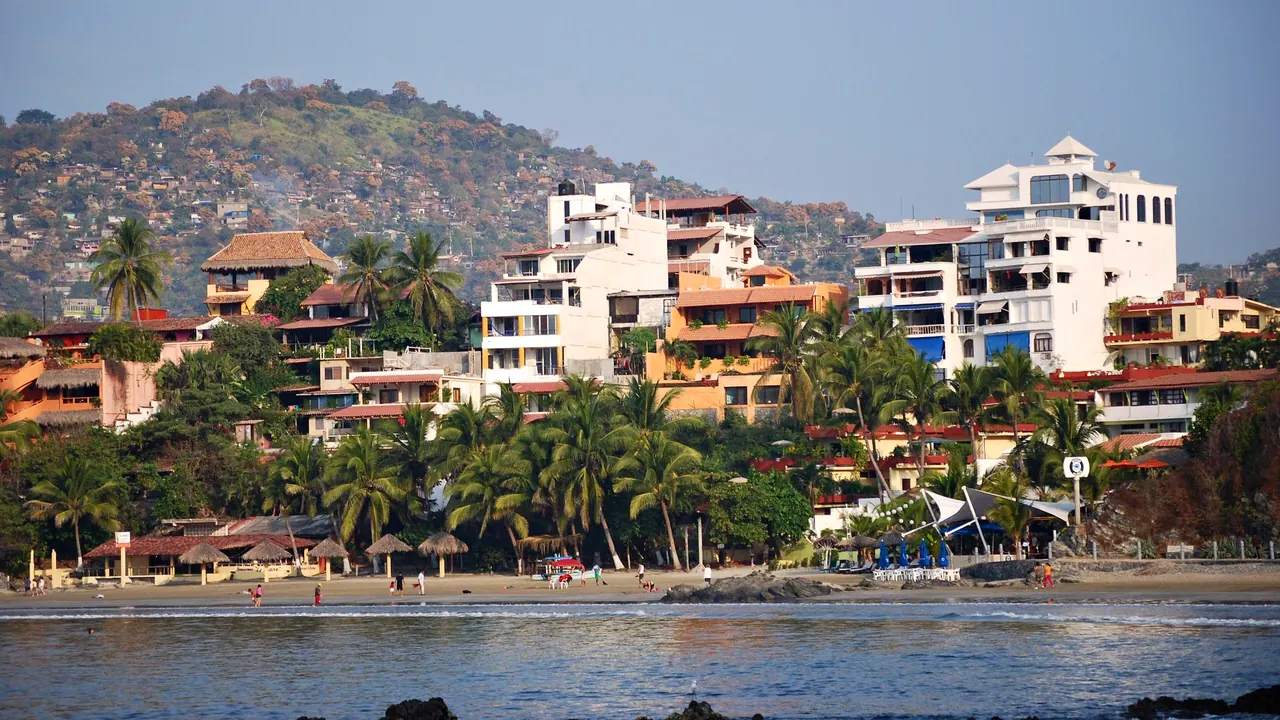
The beach and hotels of Playa Madera
- Beaches85
- Affordable cities68
- Nature & outdoors62
Photo: AlejandroLinaresGarcia, CC BY-SA 4.0, cropped
Match
43
Every category weighted equally
- Beach & sun52
- Culture & arts35
- Food & nightlife39
- Family trip51
- Outdoors48
- Relax & unwind49
- Shopping & style38
- On a budget46
Zihuatanejo in twelve categories
Our verdict on each, scored 0 to 100 against the same fixed benchmark cities, so a score means the same thing on every page.
Beaches & swimming. Scores 85 out of 100.
Food & drink. Scores 50 out of 100.
Culture & sights. Scores 15 out of 100.
Nightlife. Scores 28 out of 100.
Nature & outdoors. Scores 62 out of 100.
Day trips. Scores 22 out of 100.
Good for families. Scores 55 out of 100.
Getting around. Scores 45 out of 100.
Shopping & style. Scores 25 out of 100.
Affordability. Scores 68 out of 100.
Live music & performing arts. Scores 15 out of 100.
Wellness & relaxation. Scores 50 out of 100.
Zihuatanejo category by category
Beaches & swimming
85Beaches are the reason to come. Zihuatanejo sits on a deep, sheltered bay, and the water stays warm enough to swim in every month, from about 26°C in winter to around 30°C in late summer. Playa La Ropa is the long, calm crescent of pale sand most visitors settle on, Playa Madera is a smaller cove close to town, and Las Gatas, reached by water taxi across the bay, has an old stone reef that keeps the sea flat and clear for snorkelling. The town beach is for fishing boats more than swimming.
A short ride north, the resort strip of Ixtapa adds long open beaches, though Playa El Palmar faces the open ocean and its surf and currents call for care. Isla Ixtapa, a few minutes by boat from Playa Linda, has small, calm coves. Days here follow the beach: a morning swim, lunch under a palapa, a sunset over the bay.
Food & drink
50Eating here is about fish caught that morning. The local signature is tiritas, strips of raw fish cured in lime with onion and chilli, and pescado a la talla, split and grilled over coals, is served at palapa restaurants along Playa La Ropa and Las Gatas. Thursday is pozole day across Guerrero, when whole families sit down to bowls of the hominy stew with its long row of garnishes.
The municipal market in the centre is good for breakfasts, juices and quick plates, and the streets behind the waterfront hold taquerías and small family kitchens. There are some polished restaurants with bay views in the hills and in Ixtapa, but the range is narrow: this is a place for honest coastal cooking, not a destination for serious dining.
Culture & sights
15There is little to see in the way of sights. The small Museo Arqueológico de la Costa Grande on the waterfront gives a useful introduction to the pre-Hispanic peoples of this coast, and the old centre is a modest grid of whitewashed streets, a church and the fishermen's pier. The charm is in the working fishing town itself rather than in any monument.
Nightlife
28Evenings are gentle. In Zihuatanejo they usually mean a drink on the beach at sunset, a long dinner and a few small bars around the centre and the waterfront, many with a mostly local or long-stay crowd. Ixtapa, the hotel strip up the coast, has louder beach bars and a handful of clubs that fill up in the winter high season and over Mexican long weekends, when visitors arrive from the cities inland. Anyone hoping for a real late scene will find it thin.
Nature & outdoors
62The setting is a horseshoe bay backed by the dry, forested hills of the Sierra Madre del Sur, and most outdoor life happens on the water. Snorkelling and diving are good around Las Gatas and Isla Ixtapa, sport fishing boats go out after sailfish and marlin, and in winter humpback whales pass along the coast. Kayaks and paddleboards suit the calm bay.
South of town, the lagoon at Barra de Potosí is rich in herons, pelicans and spoonbills, and crocodiles laze in the mangrove channels near Playa Linda. Sea turtles nest on the open beaches through the second half of the year. A paved cycle path runs through Ixtapa, but hiking is limited and the heat of the wet season, roughly June to October, makes midday activity hard going.
Day trips
22Outings are short and small-scale. Ixtapa is a resort strip rather than a town, the surf village of Troncones to the north makes a relaxed beach day, and Barra de Potosí to the south is a fishing village where lunch on the sand is the main event. Under an hour by road, the Xihuacan archaeological site near Soledad de Maciel has a ball court and a small site museum, and Petatlán is known for its pilgrimage church. Anything larger, including Acapulco, is too far for an easy day out.
Good for families
55For families who want a beach vacation, it works well. La Ropa and Las Gatas have calm, warm water where small children can paddle, the town is small enough to manage without stress, and Mexican culture is warm towards children in restaurants and on the beach. Ixtapa's large resorts add pools, kids' clubs and space.
Beyond the beach there is little built for children: a boat ride to Isla Ixtapa, snorkelling, spotting crocodiles in the lagoons and turtle releases in season are the main outings. Strong sun and summer heat need planning, and some open-ocean beaches have rough surf.
Getting around
45The centre of Zihuatanejo is compact and walkable, and the waterfront path links the town beach to Playa Madera. Beyond that, most visitors rely on taxis, which are plentiful, and on local buses and colectivos that run to Playa La Ropa and up the coast to Ixtapa. Las Gatas and Isla Ixtapa are reached by boat. The roads over the hills are steep and often lack pavements, so walking between beaches is not practical, but a car is rarely needed unless you plan to explore the coast.
Shopping & style
25Shopping is modest. The artisans' market near the centre sells hammocks, embroidered clothing, painted pottery, Taxco silver and lacquerware from Olinalá in the Guerrero mountains, and a few small boutiques in the centre carry resort wear and Mexican folk art. Ixtapa has a small shopping plaza. It is enough for souvenirs, not a reason to come.
Affordability
68Day-to-day costs are low. Market meals, taquerías, palapa lunches, taxis and buses are inexpensive, and simple guesthouses and small hotels in town are good value. Prices climb in the boutique hotels on the hills above La Ropa and in the big Ixtapa resorts, and rooms are dearer in the winter high season and around Christmas and Easter. Staying in town and eating like the locals keeps a stay very affordable.
Live music & performing arts
15There is little formal performance. The town's long-running international guitar festival brings concerts to the beach and the centre once a year, and in high season some restaurants and bars have live bands, trova singers or mariachis playing in the evening. Otherwise there is no theatre or concert life to speak of.
Wellness & relaxation
50The best restorative thing about the place is its pace. Life moves slowly in the heat, there are no big sights to rush between, and many visitors simply read in the shade and swim. There is no local bathing tradition, though some places offer temazcal, the Mesoamerican sweat lodge. Spas and massage are found mainly in the boutique hotels above La Ropa and in the Ixtapa resorts, and some smaller places offer yoga.
When should you go?
Pick a month to see what it is like. The climate figures are measured averages, not a forecast.
Zihuatanejo in July
Daytime high, °C
Rainfall in the month, mm
The whole year
Shaded against this city’s own year: the deepest cell is its best month for that figure and the palest its weakest.
Where the figures come from
Zihuatanejo has no weather station within reach, so its figures come from a gridded climate model rather than a measured record, and read a broad area rather than the city itself.
Temperature and rainfall are climate normals, averaged over the years shown. Zihuatanejo: 1991-2020 normals, TerraClimate 4 km grid at the town, no weather station within 90 km.
Before you go
| Measure | Zihuatanejo |
|---|---|
| Official language | Spanish, Nahuatl, Yucatec Maya |
| Currency | Mexican Peso (MXN) |
| Sockets | AB127 V, 60 Hz |
| Driving side | Right |
| Time zone | UTC-6 |
| Emergency number | 911 |
| Elevation | 13 m |
| Main airport | Ixtapa-Zihuatanejo International Airport (ZIH)11 km from centre17 non-stop destinations |
| Public holidays this year | 9 days |
By the numbers
| Measure | Zihuatanejo |
|---|---|
| City population | 70,760 |
| Museums within 10 km | 1 |
| UNESCO World Heritage sites within 50 km | 0 |
| Swim season, months above 21 °C | 12 months |
Compare Zihuatanejo with
Every comparison with a written verdict behind it.
- Acapulco
- Guadalajara
- Guanajuato
- Huatulco
- Los Cabos
- Mazatlan
- Mexico City
- Nuevo Vallarta
- Oaxaca
- Puebla
- Puerto Escondido
- Puerto Vallarta
- San Miguel de Allende
- Sayulita