Switzerland
Grindelwald
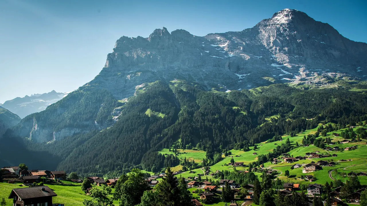
The Eiger above Grindelwald's meadows and chalets
- Nature & outdoors97
- Getting around76
- Families70
Photo: Christopher Becke, Pexels License
Grindelwald lies in Swiss Alps, which has its own page.
Match
36
Every category weighted equally
- Beach & sun35
- Culture & arts31
- Food & nightlife26
- Family trip44
- Outdoors48
- Relax & unwind38
- Shopping & style31
- On a budget32
Grindelwald in twelve categories
Our verdict on each, scored 0 to 100 against the same fixed benchmark cities, so a score means the same thing on every page.
Beaches & swimming. Scores 15 out of 100.
Food & drink. Scores 22 out of 100.
Culture & sights. Scores 7 out of 100.
Nightlife. Scores 10 out of 100.
Nature & outdoors. Scores 97 out of 100.
Day trips. Scores 63 out of 100.
Good for families. Scores 70 out of 100.
Getting around. Scores 76 out of 100.
Shopping & style. Scores 13 out of 100.
Affordability. Scores 5 out of 100.
Live music & performing arts. Scores 6 out of 100.
Wellness & relaxation. Scores 42 out of 100.
Grindelwald category by category
Beaches & swimming
15Grindelwald is a mountain village, and beach life plays no real part in a stay here. The closest swimming is at the lakes either side of Interlaken. Lake Brienz is a glacial turquoise and stays bracing, while Lake Thun warms to around 20°C in a good July or August. Both have lawns and small lido-style bathing spots, about half an hour to an hour away by train and bus. The alpine tarns above the village are for looking at, not swimming in. If water matters to your trip, think of it as an occasional summer afternoon out.
Food & drink
22Eating here is hearty alpine cooking, mostly in hotel dining rooms along the main street and in mountain restaurants at the top stations. Expect cheese fondue, raclette, rösti, sausages and Älplermagronen, the macaroni-and-potato dish of the high pastures. The best moments come from where you eat rather than the cooking itself: a terrace lunch facing the Eiger, or local alpine cheese bought straight from a summer dairy. Beyond that the choice is narrow. There are a few Asian and pizza kitchens for variety, prices are high, and nobody travels to Grindelwald for its food.
Culture & sights
7There is very little in the way of sights in the conventional sense. The village has a small local history museum covering farming, early tourism and the climbers drawn to the Eiger north face, and a whitewashed Reformed church. Old wooden chalets with carved and painted gables are scattered across the slopes. The real monument is the mountain wall itself. Anyone after museums or historic towns will need to take a train out of the valley.
Nightlife
10Evenings are quiet. In the ski season a few après-ski bars near the slopes and along the main street fill up as the lifts close, and some hotel bars keep going a little later. In summer most visitors are hikers who eat early and turn in early before a sunrise start. There are no clubs to speak of, and by late evening the village is dark and still.
Nature & outdoors
97Few places put you this close to the high Alps. The north face of the Eiger rises straight above the village, with the Wetterhorn and Schreckhorn alongside it, and gondolas run up to First and Männlichen and towards the Eiger glacier. From First, trails lead to the Bachalpsee, which mirrors the peaks in still weather. The Panoramaweg from Männlichen to Kleine Scheidegg passes directly beneath the Eiger, Mönch and Jungfrau. The rack railway climbs from Kleine Scheidegg through the mountain to the Jungfraujoch, at 3,454m, above the Aletsch Glacier.
In summer there are hundreds of kilometres of marked trails, plus via ferratas, paragliding and mountain biking. Just below the village, meltwater from the Lower Grindelwald Glacier has cut the Glacier Canyon, a narrow gorge you can walk into. In winter the Jungfrau ski region opens up long red runs, sledging tracks and winter walking paths. Weather sets the rhythm. Cloud can hide everything for days, and the high trails are clear of snow only from about June.
Day trips
63Getting out for the day is easy, because every trip starts with the train down the valley to Interlaken. From there the car-free cliff villages of Wengen and Mürren sit above the Lauterbrunnen valley. Thun has a castle above its old town, Spiez a lakeside castle, and Brienz a long tradition of woodcarving, with the Ballenberg open-air museum of rural Swiss houses close by. Lake steamers link the towns along both lakes.
The standout is Bern, about an hour and a half away. Its arcaded medieval old town is a UNESCO World Heritage Site. Lucerne is reachable too, though at a little over two hours it makes for a long day. Wine regions and larger cities are mostly further away.
Good for families
70In summer Grindelwald works very well for families who like being outdoors. At the First gondola there are a cliff walk, scooter-bikes and wheeled mountain carts for the ride back down, plus easy flat trails and adventure playgrounds at the mid-stations. Below Pfingstegg, a summer toboggan run curves down the slope. Gentle themed walks are laid out for small legs. In winter there are ski schools, nursery slopes and long sledging runs.
The village is safe and calm, trains and gondolas welcome pushchairs, and farm animals are everywhere. There are no zoos, aquariums or theme parks, though, and a rainy day leaves little to do apart from the indoor pool. Toddlers may find the high-altitude excursions hard going.
Getting around
76You do not need a car. Trains from Interlaken arrive at the station in the middle of the village, and the Wengernalp railway climbs to Kleine Scheidegg. Gondolas to First, Männlichen and the Eiger glacier start within walking distance or a short local bus ride from the centre. Timetables link the trains and lifts, so even a full day across the region involves little waiting.
The village itself is long and spread across a slope, though. Some hotels and chalets sit well above or below the main street, and the walk back up can be steep. Local buses fill those gaps. In winter, ski buses link the lift stations.
Shopping & style
13Shopping means the main street. It is lined with outdoor and ski equipment shops, rental counters, and stores selling Swiss watches, army knives, chocolate and cowbells. It is handy for walking poles or a warmer layer, and for a few classic Swiss souvenirs. Beyond that there are no boutiques, markets or department stores, and nobody comes here to shop.
Affordability
5Grindelwald is one of the most expensive places a visitor can choose. Hotel rooms and chalets cost Swiss resort prices, and even simple mountain-restaurant meals are expensive. The biggest cost is moving around. Gondolas, lift passes and above all the railway to the Jungfraujoch are central to any stay, and they cost a great deal. Regional and Swiss travel passes reduce the bill, and so do self-catering apartments and picnics from village supermarkets, but this is never a budget trip.
Live music & performing arts
6There is almost no formal performance life. In summer the village programme may include yodelling choirs, alphorn players and brass bands, plus the odd open-air concert or folk evening at a hotel. These are nice to come across but are not something to plan a trip around. Theatre and classical music mean an evening trip to the larger towns down the valley.
Wellness & relaxation
42There are no thermal springs or historic baths here, so wellness depends on the hotels. Several of the larger hotels have spas with saunas, steam rooms and indoor pools, some with picture windows facing the Eiger. The public sports centre has a pool and sauna that anyone can use. What Grindelwald adds is the pace. Cowbells, clean air and evenings on a balcony watching the light leave the north face make for a calm stay, especially out of season. If you are after a real spa culture, there is not much of one here.
When should you go?
Pick a month to see what it is like. The climate figures are measured averages, not a forecast.
Grindelwald in July
Daytime high, °C
Rainfall in the month, mm
The whole year
Shaded against this destination’s own year: the deepest cell is its best month for that figure and the palest its weakest.
Where the figures come from
Grindelwald has no weather station within reach, so its figures come from a gridded climate model rather than a measured record, and read a broad area rather than one spot.
Temperature and rainfall are climate normals, averaged over the years shown. Grindelwald: 1991-2020 normals, TerraClimate 4 km grid at the town, no weather station within 90 km.
Before you go
| Measure | Grindelwald |
|---|---|
| Official language | French, German, Italian, Romansh |
| Currency | Swiss Franc (CHF) |
| Sockets | CJ230 V, 50 Hz |
| Driving side | Right |
| Time zone | UTC+1, UTC+2 in summer |
| Emergency number | 112 |
| Elevation | 1,034 m |
| Main airport | Zürich Airport (ZRH)100 km from centre226 non-stop destinations |
| Public holidays this year | 10 days |
By the numbers
| Measure | Grindelwald |
|---|---|
| Population | 3,942 |
| People per km² | 23 |
| Museums within 10 km | 0 |
| UNESCO World Heritage sites within 50 km | 2 |
Compare Grindelwald with
Every comparison with a written verdict behind it.
- Adelboden
- Alpe d'Huez
- Andermatt
- Arosa
- Avoriaz
- Chamonix
- Châtel
- Courchevel
- Crans-Montana
- Davos
- Engelberg
- Flaine
- Gstaad
- Interlaken
- Klosters
- La Clusaz
- La Plagne
- La Rosière
- Laax
- Le Grand-Bornand
- Lenzerheide
- Les Arcs
- Les Deux Alpes
- Les Gets
- Les Menuires
- Leukerbad
- Megève
- Méribel
- Montgenèvre
- Morzine
- Mürren
- Saas-Fee
- Saint-Gervais-les-Bains
- Samnaun
- Samoëns
- Serre Chevalier
- St. Moritz
- Tignes
- Val Cenis
- Val d'Isère
- Val Thorens
- Verbier
- Wengen
- Zermatt