Chile
San Pedro de Atacama
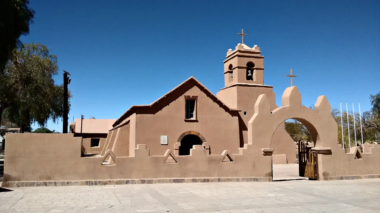
The church of San Pedro and its adobe arch
- Nature & outdoors93
- Wellness & relaxation52
- Affordable cities35
Photo: MarcosEscalier, CC BY-SA 4.0, cropped
Match
28
Every category weighted equally
- Beach & sun29
- Culture & arts23
- Food & nightlife21
- Family trip30
- Outdoors36
- Relax & unwind34
- Shopping & style24
- On a budget28
San Pedro de Atacama in twelve categories
Our verdict on each, scored 0 to 100 against the same fixed benchmark cities, so a score means the same thing on every page.
Beaches & swimming. Scores 8 out of 100.
Food & drink. Scores 25 out of 100.
Culture & sights. Scores 21 out of 100.
Nightlife. Scores 8 out of 100.
Nature & outdoors. Scores 93 out of 100.
Day trips. Scores 18 out of 100.
Good for families. Scores 22 out of 100.
Getting around. Scores 22 out of 100.
Shopping & style. Scores 20 out of 100.
Affordability. Scores 35 out of 100.
Live music & performing arts. Scores 6 out of 100.
Wellness & relaxation. Scores 52 out of 100.
San Pedro de Atacama category by category
Beaches & swimming
8This is a desert oasis at 2,400m, a long drive from the Pacific coast, so beach life plays no part in a stay. The nearest thing to a swim is a float in the salt lagoons of the Salar de Atacama. At Laguna Cejar and the Baltinache pools the water is so dense with salt that you lie on the surface without effort. It is a memorable hour, but the water is cool, the sun is fierce and there is no shade, and you are rinsing salt off afterwards rather than spending an afternoon on the sand. For a real pool day, choose a lodge with its own pool.
Food & drink
25Eating out happens along Caracoles, the dusty main street, and the lanes around the plaza. Restaurants there feed a steady flow of tour groups and backpackers. The better kitchens cook with Andean ingredients: quinoa, llama, goat cheese, chañar and the herb rica-rica, which also turns up in pisco sours and ice cream. Lunch menus with soup and a main course are the simple, honest option. Around them sit pizza places and set dinners around a fire pit, all pleasant and much alike.
It is a village of a few thousand people, so the range is narrow. There are no markets or street food to speak of, and after a few nights the menus start to repeat. Visitors come for the desert and eat to refuel.
Culture & sights
21The village itself is a low grid of adobe houses and dirt streets around a plaza shaded by pepper trees. Its landmark is the whitewashed Iglesia de San Pedro, a colonial adobe church whose ceiling is built from cactus wood lashed together with leather straps.
The more striking heritage lies just outside town. Three kilometres north, the stone walls of the Pukará de Quitor climb a hillside above the river. This Atacameño fortress was a centre of resistance to the Spanish, and it fell to a small Spanish force in 1540. The view from the top takes in the whole oasis. To the south, the round, half-buried adobe dwellings of Tulor are the remains of a farming village more than two thousand years old. All of it fits into half a day, ideally by bike, and nobody comes here for the sights. They give a quiet human backdrop to the landscape.
Nightlife
8Evenings are short. A handful of bars and restaurants on and around Caracoles serve pisco sours and beer around outdoor fire pits, mostly to travellers swapping tour stories. The village is quiet well before midnight. Many visitors are in bed early anyway, because the geyser tours leave long before dawn. The real night-time activity here is looking up: the dry, high air makes the stars spectacularly clear, and an astronomy tour is how most people spend a night out.
Nature & outdoors
93The landscape is the reason to come, and it is extraordinary. Within half an hour of the village are the eroded ridges and dunes of the Valle de la Luna and the Valle de la Muerte, good by bike, on foot or on a sandboard. The Salar de Atacama spreads south with flamingos feeding in its pools. Higher up, the El Tatio geyser field steams at over 4,300m at sunrise, and the Miscanti and Miñiques lagoons lie deep blue beneath snow-streaked volcanoes, with vicuñas grazing along the road.
Fit, acclimatised walkers can climb peaks such as Cerro Toco or Lascar, and the dry, dark skies make for some of the finest stargazing on earth. The weather is reliable all year, with sun almost every day, though nights are cold and summer can bring the occasional altiplano storm. Altitude is the constant limit: give yourself a few gentle days before going high.
Day trips
18Almost every excursion from here heads into the landscape. Places to visit in their own right are few. Toconao, a short drive south, is an oasis village built of white volcanic stone, with a free-standing bell tower and orchards in its gorge. Socaire, Machuca and Caspana are tiny Andean hamlets you usually pass through on lagoon or geyser tours. About two hours north, the old church at Chiu Chiu ranks among the oldest in Chile, and the vast open-pit copper mine at Chuquicamata near Calama makes an unusual industrial outing. The famous salt flat of Uyuni across the Bolivian border is a multi-day journey, not a day trip.
Good for families
22Older children and teenagers can love it here, with sandboarding on the dunes, floating in a salt lagoon, cycling through red canyons and looking at Saturn through a telescope. For younger ones it is tougher. The village is small, calm and easy to stroll, but nothing in it is designed for children. The big excursions mean leaving before dawn, sitting in a minibus for hours and spending time at heights over 4,000m, where altitude sickness and the bitter cold of early morning are real concerns. The sun is intense, the air very dry and the dust everywhere. Families who come usually pick the lower, shorter outings and a lodge with a pool.
Getting around
22The village takes ten minutes to cross on foot, along unpaved streets that turn dusty in the wind. Beyond it you are on your own. No public transport serves the lagoons, geysers or valleys, so most visitors book a seat on one of the many minibus tours that leave from Caracoles each morning. Others hire a car, ideally a high-clearance vehicle for the altiplano roads. Bikes rented in town are a good way to reach the Valle de la Luna and the nearby ruins, though heat, altitude and sand make it harder going than it looks. Most people arrive by bus or transfer from Calama airport, about an hour and a half away.
Shopping & style
20Shopping amounts to the craft market near the plaza and the shops along Caracoles. They sell alpaca and llama wool jumpers, hats and blankets, woven Andean textiles, carvings in volcanic stone and jewellery with Chilean lapis lazuli. Much of it is the same across the region, with some pieces from Bolivia, but a warm wool layer is genuinely useful for the freezing dawn starts. There is no other shopping here, and nobody comes for it.
Affordability
35It is an expensive place for a village, and dearer than most of Chile. Everything is trucked across the desert, and the town lives almost entirely from visitors. Rooms range from basic hostels to all-inclusive desert lodges that are among the costliest in South America, and mid-range guesthouses cost more than their simple adobe rooms suggest. Restaurant dinners are priced for tourists, and since few sights can be reached without a tour or a car, excursions and park entry fees make up a large share of any budget. Set lunch menus, self-catering and cycling to the nearby valleys help keep costs down.
Live music & performing arts
6There is essentially no performing arts life. Some restaurants bring in Andean musicians with panpipes and charango on busy evenings. The traditional dances worth seeing belong to the village's religious festivals, above all the feast of San Pedro and San Pablo and Carnival, when costumed troupes dance through the streets. Otherwise evenings are for the stars, not the stage.
Wellness & relaxation
52The great restorative experience is the Termas de Puritama, a string of natural hot pools at around 30°C stepping down a reed-filled canyon, about half an hour's drive into the hills. There is a natural thermal pool at the El Tatio geysers as well. The upmarket desert lodges have spas, massage and outdoor pools looking towards the volcanoes, and yoga and meditation sessions are easy to find in the village.
The pace itself is slow: adobe walls, shady courtyards, siestas through the hottest hours. What works against rest is the rhythm of a stay here, with alarms before dawn, long drives and the thin, dry air, which tires the body more than visitors expect. Build in a few empty days.
When should you go?
Pick a month to see what it is like. The climate figures are measured averages, not a forecast.
San Pedro de Atacama in July
Daytime high, °C
Rainfall in the month, mm
The whole year
Shaded against this city’s own year: the deepest cell is its best month for that figure and the palest its weakest.
Where the figures come from
San Pedro de Atacama has no weather station within reach, so its figures come from a gridded climate model rather than a measured record, and read a broad area rather than the city itself.
Temperature and rainfall are climate normals, averaged over the years shown. San Pedro de Atacama: 1991-2020 normals, TerraClimate 4 km grid at the town, no weather station within 90 km.
Before you go
| Measure | San Pedro de Atacama |
|---|---|
| Official language | Spanish |
| Currency | Chilean Peso (CLP) |
| Sockets | CL220 V, 50 Hz |
| Driving side | Right |
| Time zone | UTC-4, UTC-3 in summer |
| Emergency number | Police 133/134, ambulance 131, fire 132 |
| Elevation | 2,407 m |
| Main airport | El Loa Airport (CJC)86 km from centre3 non-stop destinations |
| Public holidays this year | 16 days |
By the numbers
| Measure | San Pedro de Atacama |
|---|---|
| City population | 5,347 |
| People per km² | 2,325 |
| Museums within 10 km | 1 |
| UNESCO World Heritage sites within 50 km | 1 |
Compare San Pedro de Atacama with
Every comparison with a written verdict behind it.