United States
Canyonlands
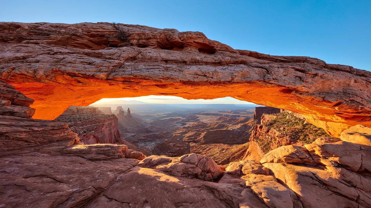
Mesa Arch at sunrise
- Nature & outdoors94
- Families45
- Getting around42
Photo: Thomas Wolf, www.foto-tw.de, CC BY-SA 3.0, cropped
Match
30
Every category weighted equally
- Beach & sun29
- Culture & arts27
- Food & nightlife23
- Family trip35
- Outdoors39
- Relax & unwind31
- Shopping & style26
- On a budget30
Canyonlands in twelve categories
Our verdict on each, scored 0 to 100 against the same fixed benchmark cities, so a score means the same thing on every page.
Beaches & swimming. Scores 7 out of 100.
Food & drink. Scores 25 out of 100.
Culture & sights. Scores 22 out of 100.
Nightlife. Scores 8 out of 100.
Nature & outdoors. Scores 94 out of 100.
Day trips. Scores 30 out of 100.
Good for families. Scores 45 out of 100.
Getting around. Scores 42 out of 100.
Shopping & style. Scores 14 out of 100.
Affordability. Scores 33 out of 100.
Live music & performing arts. Scores 14 out of 100.
Wellness & relaxation. Scores 20 out of 100.
Canyonlands category by category
Beaches & swimming
7There are no beaches here. Canyon country is high desert, and the Colorado and Green rivers are cold, silty and fast, so people go rafting on them rather than swimming. In the summer heat, people cool off in a small reservoir in the hills above Moab, in shallow eddies on calm stretches of the river, or in a motel pool. Lake Powell's shores are a long drive south and belong to a different trip.
Food & drink
25Eating here means Moab, a small town with more restaurants than its size suggests, all built around hungry hikers and cyclists. Expect burgers, Southwestern and Tex-Mex plates, pizza, a few craft-beer taprooms, food trucks and early breakfast places that feed people before sunrise starts at the trailheads. Utah's strict liquor laws shape the drinking, and the outlying towns such as Green River, Monticello and Bluff have only a handful of diners. Most visitors also do a lot of picnicking and campfire cooking, which suits the place. Nobody comes here for the food.
Culture & sights
22The heritage of canyon country is written on its rock walls. Fremont and Ancestral Puebloan petroglyphs and pictographs are everywhere: Newspaper Rock on the road to the Needles, the panels along Potash Road and Courthouse Wash near Moab, and the Great Gallery in Horseshoe Canyon. The Great Gallery's life-size painted figures are among the finest rock art in North America, but they are reached only by a long dirt drive and a hike. Small cliff granaries, Wolfe Ranch's pioneer cabin, uranium-mining relics and the small Moab Museum fill out the picture. There is little built heritage. Culture here is something you find on a trail, not in a gallery.
Nightlife
8Evenings are short. Moab has a few bars and brewpubs where rafting guides and mountain bikers gather after a long day, and they can be lively on a spring weekend. But early starts and Utah's licensing rules mean most nights end not long after dinner. The real evening activity here is looking at the stars from a campsite.
Nature & outdoors
94This is some of the most extraordinary desert country on earth. From Moab, Arches National Park and its two thousand sandstone arches are minutes away. Within an hour you reach the Island in the Sky mesa, where overlooks drop thousands of feet to the White Rim and the river gorges, and Dead Horse Point, where the Colorado makes its famous gooseneck bend. The Needles district, further south, has banded spires and long loop hikes. The Maze is one of the most remote places in the lower forty-eight states.
All of it can be explored actively. There is world-famous slickrock mountain biking, multi-day rafting through Cataract and Westwater canyons, calm-water paddling, canyoneering, climbing on Wall Street and in Indian Creek, and four-wheel-drive tracks such as the White Rim Road. The La Sal Mountains rise to alpine meadows above the desert. Spring and autumn are the best seasons. Summer days often pass 38°C, so people go out at dawn and stay in at midday, and the night skies are dark enough to show the Milky Way.
Day trips
30Most days out here lead to more landscape, not to other towns. The places worth a visit as places are few and small. Bluff, on the San Juan River, has pioneer stone houses and rock art nearby. In Blanding, the Edge of the Cedars museum has an excellent collection of Ancestral Puebloan pottery next to a ruin. The Hovenweep towers stand on the Colorado border. Green River is a quiet melon-growing town with a river history museum. Eastward, Grand Junction and the orchards and vineyards of Palisade make a pleasant day across the state line. Mesa Verde's cliff dwellings are about two and a half hours away, so they are better seen as a separate stop.
Good for families
45For families who like the outdoors, this can be a memorable trip. In Arches, short walks reach Sand Dune Arch, Double Arch and the Windows, and the national parks run Junior Ranger programmes. Near Moab, children can see dinosaur tracks and a small dinosaur park, and half-day float trips on calm stretches of the Colorado suit younger children. Motels with pools and plenty of campgrounds make bases easy. The drawbacks are serious, though: many overlooks have sheer unfenced drops, summer afternoons are dangerously hot, distances between sights mean long hours in the car, and there are no zoos, theme parks or rainy-day attractions.
Getting around
42A car is essential, and once you have one, most of the region is easy. Moab sits on the main highway, Arches begins just outside town, and good paved roads reach Island in the Sky and Dead Horse Point in under an hour. The Needles is about an hour and a half south. Moab itself is walkable, and a paved bike path follows the river north towards the Arches entrance. Public transport is barely worth mentioning. In spring and autumn the queue of cars at the Arches gate can be long, and the remoter corners, such as the Maze, Horseshoe Canyon and the White Rim, need high-clearance vehicles, long dirt drives or a guided tour.
Shopping & style
14Moab's Main Street covers the practical needs well, with bike and climbing shops, camping gear, rock and fossil shops, some local galleries and plenty of souvenir T-shirts. Further south around Bluff and Blanding, trading posts sell Navajo rugs, silver jewellery and pottery, the most interesting things to take home. Beyond that there is little to shop for.
Affordability
33Moab is a small town that fills up in spring and autumn, and its rooms are priced accordingly. Ordinary motels in the main seasons cost far more than their comfort would suggest, and eating out is at American tourist-town levels. Guided rafting, jeep and canyoneering trips add up quickly. The landscape itself is the cheap part. A single park pass covers the national parks, the public lands around them offer many campgrounds and free dispersed camping, and travellers who camp, cook and drive themselves can see the best of the region for much less. Winter is cheapest but quiet, and many tours stop running.
Live music & performing arts
14For most of the year there is almost nothing to see on stage beyond occasional music in Moab's bars and outdoor summer shows. The exception is the Moab Music Festival, a chamber-music festival running since the early 1990s and held from late summer into early autumn. Its concerts take place in town and in remarkable settings: sandstone grottoes reached by jet boat down the Colorado, and riverside ranches. For a classical-music lover, it is worth timing a trip around it.
Wellness & relaxation
20There are no thermal baths here and no tradition of bathing. Wellness comes down to a few day spas and massage studios in Moab, which mainly serve sore hikers and cyclists, and some resort lodges along the river. What the region does offer is quiet. Sunrise from a canyon rim, a desert silence that is rare elsewhere, and dark night skies give a restful feeling to a stay that is otherwise built around physical effort.
Where to stay in Canyonlands
Moab is the natural base for almost everyone, and on a first visit you need nowhere else. Arches begins just outside town, Island in the Sky and Dead Horse Point are less than an hour's drive, and the river outfitters, bike shops and early breakfast places are all on the doorstep. It suits families, who get motels with pools and easy short walks nearby, and mountain bikers, climbers and rafters, who can find a brewpub at the end of the day. Book early for spring and autumn, when the town fills up.
The Needles is about an hour and a half south of Moab, so on a longer trip or a second visit it makes sense to move. Monticello puts you closer to the Needles road. Bluff, on the San Juan River, suits a quiet stay with rock art, pioneer stone houses, trading posts and easy drives to Blanding and Hovenweep, but evenings there mean one of a handful of diners. In the north, quiet Green River is the practical base for the long drive to Horseshoe Canyon.
For walkers and anyone keen on starting at dawn, the park campgrounds and free camping on the surrounding public land put you close to the trailheads and under very dark skies. In summer, though, camping means midday heat with little shade. Most trips need one base, or two at most.
When should you go?
Pick a month to see what it is like. The climate figures are measured averages, not a forecast.
Canyonlands in July
Daytime high, °C
Rainfall in the month, mm
The whole year
Shaded against this destination’s own year: the deepest cell is its best month for that figure and the palest its weakest.
Where the figures come from
Canyonlands has no weather station within reach, so its figures come from a gridded climate model rather than a measured record, and read a broad area rather than one spot.
Temperature and rainfall are climate normals, averaged over the years shown. Canyonlands: 2001-2020 normals, NASA POWER reanalysis grid, no weather station within 90 km.
Before you go
| Measure | Canyonlands |
|---|---|
| Currency | US Dollar (USD) |
| Sockets | AB120 V, 60 Hz |
| Driving side | Right |
| Time zone | UTC-7, UTC-6 in summer |
| Emergency number | 911 |
| Main airport | Canyonlands Regional Airport (CNY)2 non-stop destinations |
| Public holidays this year | 12 days |
Compare Canyonlands with
Every comparison with a written verdict behind it.
- Arches
- Bryce Canyon
- California
- Death Valley
- Glacier National Park
- Grand Canyon
- Grand Teton
- Joshua Tree
- Kings Canyon
- Rocky Mountain National Park
- Sequoia
- Yellowstone
- Yosemite
- Zion