United States
Panama City Beach
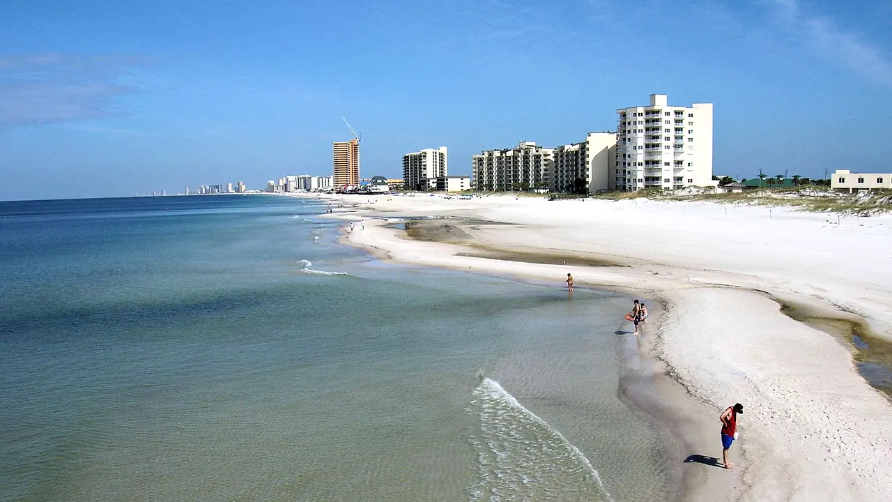
White sand and the hotel line from the St. Andrews jetty
- Beaches87
- Families72
- Nature & outdoors52
Photo: j.s. clark/ "Image by jsclark.net.", CC BY-SA 2.0, cropped
Match
38
Every category weighted equally
- Beach & sun46
- Culture & arts29
- Food & nightlife31
- Family trip46
- Outdoors44
- Relax & unwind42
- Shopping & style32
- On a budget39
Panama City Beach in twelve categories
Our verdict on each, scored 0 to 100 against the same fixed benchmark cities, so a score means the same thing on every page.
Beaches & swimming. Scores 87 out of 100.
Food & drink. Scores 33 out of 100.
Culture & sights. Scores 12 out of 100.
Nightlife. Scores 30 out of 100.
Nature & outdoors. Scores 52 out of 100.
Day trips. Scores 42 out of 100.
Good for families. Scores 72 out of 100.
Getting around. Scores 15 out of 100.
Shopping & style. Scores 28 out of 100.
Affordability. Scores 44 out of 100.
Live music & performing arts. Scores 18 out of 100.
Wellness & relaxation. Scores 28 out of 100.
Panama City Beach category by category
Beaches & swimming
87The beach is the reason the town exists. About 43km of fine, powder-white quartz sand runs along the Gulf, and the shallow water is a clear green when the sea is calm. Condos and hotels line much of the shore. The quieter stretches are at the western end and inside St. Andrews State Park, where a jetty-sheltered lagoon makes an easy swim for children, and boats run out to the undeveloped sands of Shell Island.
From late May to October the sea reaches about 28-30°C. In winter it falls to around 17°C and the beach becomes a place to walk. Rip currents are a real danger, so watch the flag system. Double red flags mean the water is closed.
Food & drink
33Eating here means Gulf seafood served casually. Expect fried or blackened grouper, shrimp baskets, raw and baked oysters from the nearby bays, and fish sandwiches eaten at open-air shacks and dockside decks. Along Front Beach Road and around the shopping areas, national chains and big themed restaurants make up most of the choice. A few kitchens near the lagoon and on the quieter western end cook more carefully, but there is little fine dining and no local food culture beyond the seafood.
Culture & sights
12There is very little to see here in the usual sense. The beach strip is mostly condo towers and attractions built after the mid-twentieth century. The small Man in the Sea Museum covers diving history and the navy's underwater research in the area. Across the bay, Panama City's St. Andrews district and its downtown have some older streets and a waterfront. Visitors who want history or museums have to drive further.
Nightlife
30Going out here means beach bars with decks over the sand, tiki huts serving frozen drinks at sunset, and sports bars and dockside places around Pier Park and the lagoon. A cover band or a DJ often plays, and there is some dancing on summer weekends. There is no real club scene and no cocktail-bar culture, and few places stay busy into the small hours.
The calendar decides the mood. In March, spring break brings college crowds and the strip along Front Beach Road turns loud and rowdy, which suits students and few others. Summer evenings are lively in a relaxed, family-resort way, good for a drink with your feet in the sand after a beach day. The rest of the year the town is quiet by mid-evening, and in winter many bars keep short seasons.
Nature & outdoors
52The landscape is flat but coastal. St. Andrews State Park has tall white dunes, pine flatwoods and a lagoon for snorkelling. At the western edge, Camp Helen State Park borders one of the rare coastal dune lakes found along this coast. Most of the outdoor life happens on the water: dolphin-watching trips, kayaking and paddleboarding on St. Andrew Bay, deep-sea and pier fishing, and diving on the artificial reefs and wrecks offshore. Inland, the conservation trails and state forest are pleasant for walking and cycling. There are no hills, and the summer heat and humidity are heavy.
Day trips
42The best outing goes west along Scenic Highway 30A. Seaside, WaterColor and Rosemary Beach are planned towns of pastel cottages, town squares and gallery streets, each under an hour away. To the east, Apalachicola is an old cotton and oyster port with brick warehouses and a working waterfront, about an hour and a half by car. Port St. Joe and Mexico Beach are on the way. Destin's harbour is around an hour west, and Pensacola's historic district and naval aviation museum are near the two-hour limit, as is Tallahassee. All these trips need a car.
Good for families
72Most visitors come as families. The water is shallow and warm in summer, and a condo with a kitchen and a pool is the normal way to stay. Children have plenty to do: a large water park, a long-running marine park with dolphin shows, a small zoo, an upside-down science attraction, and go-kart tracks and mini-golf courses all along Front Beach Road. The lagoon at St. Andrews State Park is a safe place for small children to snorkel. Two things to plan around: avoid March, when spring break makes the strip rowdy, and take the beach flags seriously.
Getting around
15The town stretches about 43km along one main beach road and a parallel highway, and you need a car for almost everything. A local trolley-bus network runs along the main roads, but it is slow and sparse. Pavements come and go, and there are no shady streets to walk. Once parked, walking along the sand between nearby beach accesses is pleasant, and summer traffic on Front Beach Road can crawl.
Shopping & style
28Shopping means Pier Park, a large open-air centre near the city pier with mainstream American chain stores and a department store. Add the giant beachwear and souvenir warehouses along the strip, with their shark-mouth entrances, and surf shops for swimwear and gear. There is no luxury or design shopping and almost nothing made locally. The boutiques in the 30A towns to the west are the best option for something more individual.
Affordability
44This is one of the more moderately priced beaches on this coast. Condo rentals with kitchens let families cook rather than eat out, and outside summer and the spring break weeks rates drop sharply, with long winter stays especially cheap. Restaurant meals, drinks, attractions and car hire still cost what they do at any American resort, and a car is needed. Peak summer weeks on the beachfront are not cheap.
Live music & performing arts
18Live performance here is mostly cover bands and acoustic sets at beach bars and on restaurant decks, plus some outdoor concerts at the shopping centre in summer. Across the bay, Panama City has a civic centre and a restored historic theatre with a modest season of touring shows and local productions. There is no opera, orchestra or theatre scene worth planning a trip around.
Wellness & relaxation
28There is no bathing or spa tradition. Wellness means a few resort spas and day spas offering massages and facials, with yoga on the sand now and then. The calm comes from the setting more than from any facilities. From autumn to spring the beach empties, long walks at sunset are easy and the pace slows a great deal. In summer and spring break the town is loud and crowded.
When should you go?
Pick a month to see what it is like. The climate figures are measured averages, not a forecast.
Panama City Beach in July
Daytime high, °C
Rainfall in the month, mm
The whole year
Shaded against this city’s own year: the deepest cell is its best month for that figure and the palest its weakest.
Where the figures come from
Panama City Beach has no rain gauge within 25 km of the centre, so its rainfall comes from a gridded climate dataset read at the city rather than from a gauge further away.
Temperature and rainfall are climate normals, averaged over the years shown. Panama City Beach: 1971-2000 (rainfall 1991-2020) normals, Tyndall Air Force Base (24.6 km from centre).
Before you go
| Measure | Panama City Beach |
|---|---|
| Currency | US Dollar (USD) |
| Sockets | AB120 V, 60 Hz |
| Driving side | Right |
| Time zone | UTC-6, UTC-5 in summer |
| Emergency number | 911 |
| Elevation | 3 m |
| Main airport | Northwest Florida Beaches International Airport (ECP)20 km from centre19 non-stop destinations |
| Public holidays this year | 11 days |
By the numbers
| Measure | Panama City Beach |
|---|---|
| City population | 18,094 |
| People per km² | 375 |
| Museums within 10 km | 0 |
| UNESCO World Heritage sites within 50 km | 0 |
| Swim season, months above 21 °C | 7 months |
Compare Panama City Beach with
Every comparison with a written verdict behind it.
- Asheville
- Atlanta
- Austin
- Boca Raton
- Charleston
- Clearwater
- Cocoa Beach
- Daytona Beach
- Destin
- Fort Lauderdale
- Fort Myers
- Galveston
- Gatlinburg
- Gulf Shores
- Houston
- Key West
- Memphis
- Miami
- Miami Beach
- Myrtle Beach
- Naples, Florida
- Nashville
- New Orleans
- Orange Beach
- Orlando
- Palm Beach
- Pensacola
- Pigeon Forge
- Sarasota
- Savannah
- St. Augustine
- St. Pete Beach
- St. Petersburg, Florida
- Tampa
- Virginia Beach
- West Palm Beach
- Wilmington