United States
Death Valley
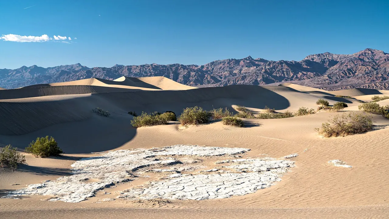
Sand dunes below the mountains of Death Valley
- Nature & outdoors88
- Wellness & relaxation45
- Getting around33
Photo: Anthony Brown, Pexels License
Death Valley lies in California, which has its own page.
Match
24
Every category weighted equally
- Beach & sun25
- Culture & arts21
- Food & nightlife17
- Family trip28
- Outdoors35
- Relax & unwind29
- Shopping & style19
- On a budget25
Death Valley in twelve categories
Our verdict on each, scored 0 to 100 against the same fixed benchmark cities, so a score means the same thing on every page.
Beaches & swimming. Scores 3 out of 100.
Food & drink. Scores 12 out of 100.
Culture & sights. Scores 15 out of 100.
Nightlife. Scores 3 out of 100.
Nature & outdoors. Scores 88 out of 100.
Day trips. Scores 28 out of 100.
Good for families. Scores 25 out of 100.
Getting around. Scores 33 out of 100.
Shopping & style. Scores 3 out of 100.
Affordability. Scores 30 out of 100.
Live music & performing arts. Scores 8 out of 100.
Wellness & relaxation. Scores 45 out of 100.
Death Valley category by category
Beaches & swimming
3There is no beach and no open water to swim in. The salt flats and old lakebeds are dry for almost all of the year. The only places to swim are the spring-fed pools at the Furnace Creek resort area, and those are for guests. If you want a swimming vacation, look elsewhere. If you come here, swimming is a pool at the end of a day's driving.
Food & drink
12Eating here is something you organise, not something you look forward to. You eat in the lodge dining rooms and saloons at Furnace Creek, Stovepipe Wells and Panamint Springs, buy groceries at general stores, or stop at diners in the small towns outside the park such as Beatty and Shoshone. The one local speciality is dates. They grow at a date farm in a canyon near Tecopa and turn up in shakes and bread. Most visitors bring a cool box, fill up on supplies before they drive in, and eat simply.
Culture & sights
15The human history is about mining and survival. At Harmony Borax Works, the ruins of the plant that sent out the famous twenty-mule teams sit beside the salt flats. Up in the Panamint Range, the beehive-shaped charcoal kilns at Wildrose are the best-preserved of their kind in the West. The visitor centre at Furnace Creek explains the borax era and the Timbisha Shoshone, who still live in the valley. Old mine workings and abandoned camps are scattered along the back roads. It is interesting background to the landscape, but you won't plan a trip around it.
Nightlife
3Nobody goes out at night. The saloons at Stovepipe Wells and Furnace Creek serve a beer after a long day and are quiet by mid-evening. What fills the night is the sky. Death Valley is one of the darkest places in the country, and on a moonless winter night the Milky Way is bright enough to throw shadows.
Nature & outdoors
88This is one of the great desert landscapes on earth. Badwater Basin lies 86m below sea level, a white crust of salt polygons. Telescope Peak rises more than 3,000m above it and is often snow-capped in winter. Between the two you get the golden badlands of Zabriskie Point, the colourful Artist's Palette, the Mesquite Flat dunes at Stovepipe Wells, the marble-walled narrows of Mosaic Canyon, the Ubehebe volcanic crater and the moving rocks of the remote Racetrack. In wet springs the valley floor flowers.
The season decides everything. From about November to March, days are mild and hiking the canyons, ridges and dunes is a pleasure. In summer the valley regularly passes 50°C, and walking is dangerous after mid-morning. A lot of the best country is on rough dirt roads that need a high-clearance vehicle. There are no lakes or rivers to paddle, and you come here for the rock, the light and the space.
Day trips
28Outside the park there are only a few places to visit, and they are far apart. Rhyolite, just over the Nevada line near Beatty, is the most photogenic ghost town in the region. Its ruined bank and bottle house stand in open desert. To the south are the hot-spring hamlet of Tecopa and the old railway stop of Shoshone. To the west, about two hours away, are the old Western-film town of Lone Pine and Manzanar, the Second World War incarceration camp that is preserved as a sobering historic site. Las Vegas is about two hours east. Most days here are spent inside the park itself.
Good for families
25Older children who like adventure can love it. They can slide down the dunes at Stovepipe Wells, crunch across the salt at Badwater, work through the park's Junior Ranger programme and look at a sky full of stars. Families do best in winter, staying at Furnace Creek where there are pools and the main sights are within a short drive. But there is nothing built for children, the distances are long, shops and fuel are few, and the heat outside the cool months is a real danger to small children. Plan to carry plenty of water and keep the days short.
Getting around
33You need a car. There is no public transport, and the nearest big airport is in Las Vegas, about two hours from Furnace Creek. The main paved roads are quiet and easy to drive, and they reach Badwater, Zabriskie Point, Dante's View and the dunes. But this is a huge park, and an hour or more between areas is normal. Fuel stations are few and far apart. The Racetrack, Titus Canyon and other back-country highlights are on rough dirt roads that need a high-clearance vehicle, so fill the tank and carry spare water.
Shopping & style
3There is nothing to shop for beyond supplies. You'll find general stores, gift counters at the visitor centre and lodges selling maps, books and borax souvenirs, and dates from the farm near Tecopa. Stock up in Las Vegas or Pahrump on the way in.
Affordability
30Staying inside the park is expensive. There are only a few lodgings, so rooms and meals at Furnace Creek and Stovepipe Wells cost what remote resorts charge, and petrol in the valley costs far more than in nearby towns. The cheapest way to see it is to camp in the park's campgrounds, bring your own food, and fill up with fuel and groceries before you drive in. Another option is to stay in the motel towns of Beatty or Pahrump and drive in each day, but that means long hours behind the wheel.
Live music & performing arts
8The one stage is the Amargosa Opera House at Death Valley Junction, just outside the park. It is a small adobe theatre whose walls are painted with an imagined audience, and it puts on occasional shows. Many visitors stop just to see the building. Apart from that there is no live music or theatre in the region.
Wellness & relaxation
45Rest here comes from silence and warm water. At Furnace Creek, spring-fed pools stay warm through the winter, and the resort there has a spa. Tecopa, about an hour and a quarter south, is a scruffy, likeable hamlet built around natural mineral hot springs. Its soaking pools are simple and best at night under the stars. The deep quiet of the desert in the cool months, with no traffic and no crowds, is the real draw. But the bathing is small and rustic, and the long drives between sights mean a stay is rarely as slow as it sounds.
Where to stay in Death Valley
Furnace Creek is the natural base for a first visit. It sits in the middle of the valley, a short drive from Badwater, Zabriskie Point and Dante's View, and has the visitor centre, a general store, the warm spring-fed pools and the park's main campground. It suits families in winter and anyone who wants short drives and a swim at the end of the day, though rooms and meals here cost what remote resorts charge.
Stovepipe Wells, about half an hour north-west, is smaller and quieter, with a lodge, a saloon and a campground beside the Mesquite Flat dunes and close to Mosaic Canyon. It suits walkers and photographers, and it puts you nearer Titus Canyon and the road north to Ubehebe Crater. Panamint Springs, on the western edge, is the most remote of the three and suits drivers heading for the Wildrose kilns, Telescope Peak or Lone Pine.
Outside the park, the motel towns of Beatty and Pahrump cost less but mean long hours at the wheel each day, although Beatty is handy for Rhyolite. Tecopa's simple hot springs make a restful night or two in the south. One base is enough for a short trip. On a longer one, splitting the stay between Furnace Creek and Stovepipe Wells cuts the driving.
When should you go?
Pick a month to see what it is like. The climate figures are measured averages, not a forecast.
Death Valley in July
Daytime high, °C
Rainfall in the month, mm
The whole year
Shaded against this destination’s own year: the deepest cell is its best month for that figure and the palest its weakest.
Where the figures come from
Death Valley has no weather station within reach, so its figures come from a gridded climate model rather than a measured record, and read a broad area rather than one spot.
Temperature and rainfall are climate normals, averaged over the years shown. Death Valley: 1991-2020 normals, TerraClimate 4 km grid at the town, no weather station within 90 km.
Before you go
| Measure | Death Valley |
|---|---|
| Currency | US Dollar (USD) |
| Sockets | AB120 V, 60 Hz |
| Driving side | Right |
| Time zone | UTC-8, UTC-7 in summer |
| Emergency number | 911 |
| Main airport | Harry Reid International Airport (LAS)160 non-stop destinations |
| Public holidays this year | 13 days |
Compare Death Valley with
Every comparison with a written verdict behind it.
- Arches
- Bryce Canyon
- Canyonlands
- Grand Canyon
- Grand Teton
- Joshua Tree
- Kings Canyon
- Redwood National Park
- Rocky Mountain National Park
- Sequoia
- Yellowstone
- Yosemite
- Zion